You are here: Home > Network List > IU - Global Seismograph Network (GSN - IRIS/USGS) Stations List
> Station POHA Pohakuloa, Hawaii, USA > Earthquake Result Viewer
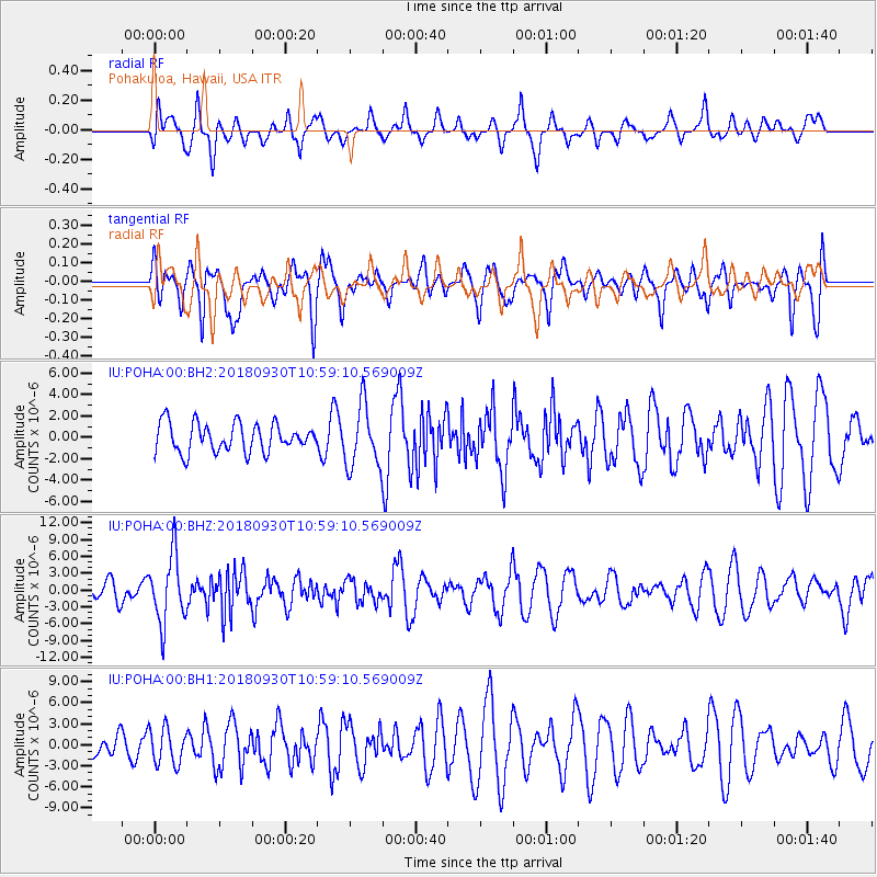
POHA Pohakuloa, Hawaii, USA - Earthquake Result Viewer
*The percent match for this event was below the threshold and hence no stack was calculated.
| Earthquake location: |
Fiji Islands Region |
| Earthquake latitude/longitude: |
-18.4/-178.1 |
| Earthquake time(UTC): |
2018/09/30 (273) 10:52:23 GMT |
| Earthquake Depth: |
551 km |
| Earthquake Magnitude: |
6.6 mww |
| Earthquake Catalog/Contributor: |
NEIC PDE/us |
|
| Network: |
IU Global Seismograph Network (GSN - IRIS/USGS) |
| Station: |
POHA Pohakuloa, Hawaii, USA |
| Lat/Lon: |
19.76 N/155.53 W |
| Elevation: |
1990 m |
|
| Distance: |
43.9 deg |
| Az: |
31.419 deg |
| Baz: |
211.709 deg |
| Ray Param: |
$rayparam |
*The percent match for this event was below the threshold and hence was not used in the summary stack. |
|
| Radial Match: |
47.489788 % |
| Radial Bump: |
400 |
| Transverse Match: |
63.70032 % |
| Transverse Bump: |
400 |
| SOD ConfigId: |
3045211 |
| Insert Time: |
2018-10-14 11:09:47.014 +0000 |
| GWidth: |
2.5 |
| Max Bumps: |
400 |
| Tol: |
0.001 |
|
Signal To Noise
| Channel | StoN | STA | LTA |
| IU:POHA:00:BHZ:20180930T10:59:10.569009Z | 4.099929 | 5.97674E-6 | 1.4577668E-6 |
| IU:POHA:00:BH1:20180930T10:59:10.569009Z | 0.7515619 | 2.5634927E-6 | 3.4108873E-6 |
| IU:POHA:00:BH2:20180930T10:59:10.569009Z | 2.1947205 | 2.9071034E-6 | 1.3245893E-6 |
| Arrivals |
| Ps | |
| PpPs | |
| PsPs/PpSs | |


