You are here: Home > Network List > IW - Intermountain West Stations List
> Station MOOW Moose Ponds, Wyoming, USA > Earthquake Result Viewer
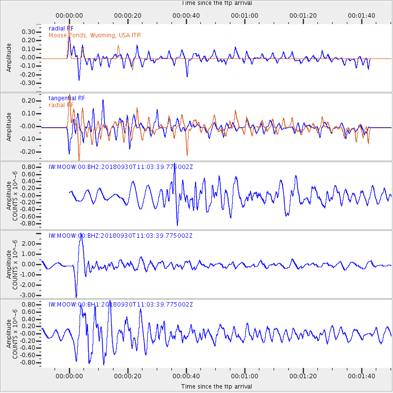
MOOW Moose Ponds, Wyoming, USA - Earthquake Result Viewer
*The percent match for this event was below the threshold and hence no stack was calculated.
| Earthquake location: |
Fiji Islands Region |
| Earthquake latitude/longitude: |
-18.4/-178.1 |
| Earthquake time(UTC): |
2018/09/30 (273) 10:52:23 GMT |
| Earthquake Depth: |
551 km |
| Earthquake Magnitude: |
6.6 mww |
| Earthquake Catalog/Contributor: |
NEIC PDE/us |
|
| Network: |
IW Intermountain West |
| Station: |
MOOW Moose Ponds, Wyoming, USA |
| Lat/Lon: |
43.75 N/110.74 W |
| Elevation: |
2128 m |
|
| Distance: |
87.2 deg |
| Az: |
42.037 deg |
| Baz: |
241.34 deg |
| Ray Param: |
$rayparam |
*The percent match for this event was below the threshold and hence was not used in the summary stack. |
|
| Radial Match: |
77.0611 % |
| Radial Bump: |
400 |
| Transverse Match: |
83.260216 % |
| Transverse Bump: |
400 |
| SOD ConfigId: |
3045211 |
| Insert Time: |
2018-10-14 11:10:16.944 +0000 |
| GWidth: |
2.5 |
| Max Bumps: |
400 |
| Tol: |
0.001 |
|
Signal To Noise
| Channel | StoN | STA | LTA |
| IW:MOOW:00:BHZ:20180930T11:03:39.775002Z | 9.591892 | 1.5988921E-6 | 1.6669205E-7 |
| IW:MOOW:00:BH1:20180930T11:03:39.775002Z | 5.5337358 | 4.1340542E-7 | 7.4706385E-8 |
| IW:MOOW:00:BH2:20180930T11:03:39.775002Z | 1.3559214 | 2.1854535E-7 | 1.6117849E-7 |
| Arrivals |
| Ps | |
| PpPs | |
| PsPs/PpSs | |


