You are here: Home > Network List > CI - Caltech Regional Seismic Network Stations List
> Station SMM Simmler, CA, USA > Earthquake Result Viewer
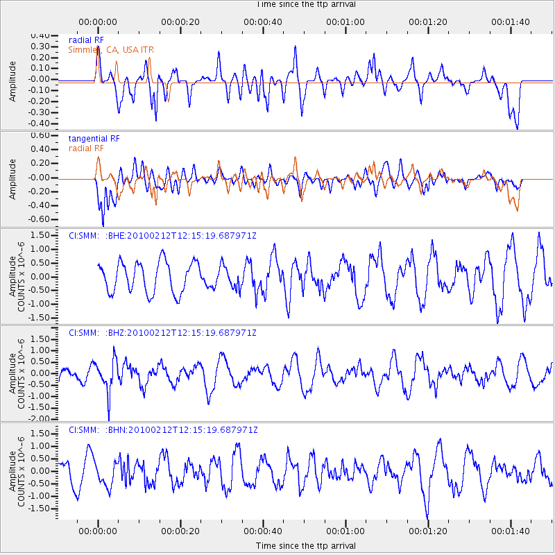
SMM Simmler, CA, USA - Earthquake Result Viewer
*The percent match for this event was below the threshold and hence no stack was calculated.
| Earthquake location: |
Mendoza Province, Argentina |
| Earthquake latitude/longitude: |
-33.6/-68.8 |
| Earthquake time(UTC): |
2010/02/12 (043) 12:03:38 GMT |
| Earthquake Depth: |
148 km |
| Earthquake Magnitude: |
5.6 MB, 5.8 MW, 5.8 MW |
| Earthquake Catalog/Contributor: |
WHDF/NEIC |
|
| Network: |
CI Caltech Regional Seismic Network |
| Station: |
SMM Simmler, CA, USA |
| Lat/Lon: |
35.31 N/120.00 W |
| Elevation: |
599 m |
|
| Distance: |
83.7 deg |
| Az: |
320.108 deg |
| Baz: |
139.129 deg |
| Ray Param: |
$rayparam |
*The percent match for this event was below the threshold and hence was not used in the summary stack. |
|
| Radial Match: |
45.904877 % |
| Radial Bump: |
386 |
| Transverse Match: |
60.64762 % |
| Transverse Bump: |
400 |
| SOD ConfigId: |
306082 |
| Insert Time: |
2010-05-06 06:37:50.285 +0000 |
| GWidth: |
2.5 |
| Max Bumps: |
400 |
| Tol: |
0.001 |
|
Signal To Noise
| Channel | StoN | STA | LTA |
| CI:SMM: :BHZ:20100212T12:15:19.687971Z | 2.3376482 | 7.003248E-7 | 2.995852E-7 |
| CI:SMM: :BHN:20100212T12:15:19.687971Z | 1.188136 | 4.723207E-7 | 3.975308E-7 |
| CI:SMM: :BHE:20100212T12:15:19.687971Z | 0.7111224 | 3.9116037E-7 | 5.500606E-7 |
| Arrivals |
| Ps | |
| PpPs | |
| PsPs/PpSs | |


