You are here: Home > Network List > TA - USArray Transportable Network (new EarthScope stations) Stations List
> Station R11A Troy Canyon, Currant, NV, USA > Earthquake Result Viewer
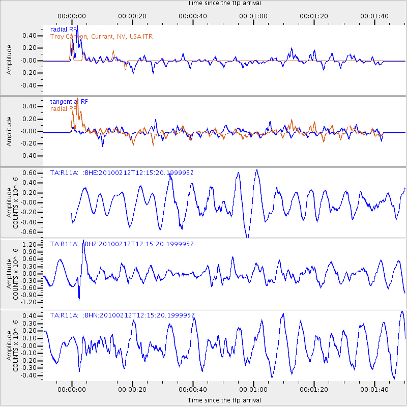
R11A Troy Canyon, Currant, NV, USA - Earthquake Result Viewer
*The percent match for this event was below the threshold and hence no stack was calculated.
| Earthquake location: |
Mendoza Province, Argentina |
| Earthquake latitude/longitude: |
-33.6/-68.8 |
| Earthquake time(UTC): |
2010/02/12 (043) 12:03:38 GMT |
| Earthquake Depth: |
148 km |
| Earthquake Magnitude: |
5.6 MB, 5.8 MW, 5.8 MW |
| Earthquake Catalog/Contributor: |
WHDF/NEIC |
|
| Network: |
TA USArray Transportable Network (new EarthScope stations) |
| Station: |
R11A Troy Canyon, Currant, NV, USA |
| Lat/Lon: |
38.35 N/115.59 W |
| Elevation: |
1756 m |
|
| Distance: |
83.8 deg |
| Az: |
324.792 deg |
| Baz: |
142.277 deg |
| Ray Param: |
$rayparam |
*The percent match for this event was below the threshold and hence was not used in the summary stack. |
|
| Radial Match: |
70.52551 % |
| Radial Bump: |
332 |
| Transverse Match: |
54.259052 % |
| Transverse Bump: |
384 |
| SOD ConfigId: |
306082 |
| Insert Time: |
2010-05-06 06:42:46.298 +0000 |
| GWidth: |
2.5 |
| Max Bumps: |
400 |
| Tol: |
0.001 |
|
Signal To Noise
| Channel | StoN | STA | LTA |
| TA:R11A: :BHZ:20100212T12:15:20.199995Z | 2.5944726 | 6.3911955E-7 | 2.4633889E-7 |
| TA:R11A: :BHN:20100212T12:15:20.199995Z | 0.64151865 | 1.3477758E-7 | 2.1009144E-7 |
| TA:R11A: :BHE:20100212T12:15:20.199995Z | 1.6210164 | 3.5094922E-7 | 2.1649949E-7 |
| Arrivals |
| Ps | |
| PpPs | |
| PsPs/PpSs | |


