You are here: Home > Network List > TA - USArray Transportable Network (new EarthScope stations) Stations List
> Station X18A Snowflake, AZ, USA > Earthquake Result Viewer
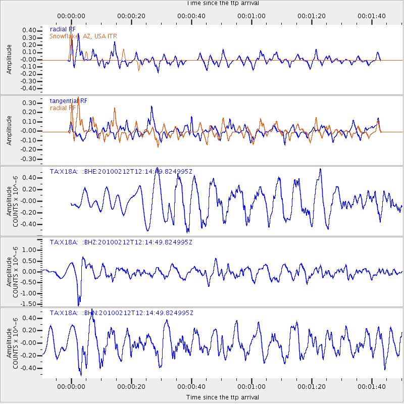
X18A Snowflake, AZ, USA - Earthquake Result Viewer
*The percent match for this event was below the threshold and hence no stack was calculated.
| Earthquake location: |
Mendoza Province, Argentina |
| Earthquake latitude/longitude: |
-33.6/-68.8 |
| Earthquake time(UTC): |
2010/02/12 (043) 12:03:38 GMT |
| Earthquake Depth: |
148 km |
| Earthquake Magnitude: |
5.6 MB, 5.8 MW, 5.8 MW |
| Earthquake Catalog/Contributor: |
WHDF/NEIC |
|
| Network: |
TA USArray Transportable Network (new EarthScope stations) |
| Station: |
X18A Snowflake, AZ, USA |
| Lat/Lon: |
34.53 N/109.95 W |
| Elevation: |
1751 m |
|
| Distance: |
78.0 deg |
| Az: |
326.254 deg |
| Baz: |
145.845 deg |
| Ray Param: |
$rayparam |
*The percent match for this event was below the threshold and hence was not used in the summary stack. |
|
| Radial Match: |
55.048477 % |
| Radial Bump: |
368 |
| Transverse Match: |
38.51068 % |
| Transverse Bump: |
325 |
| SOD ConfigId: |
306082 |
| Insert Time: |
2010-05-06 06:43:09.486 +0000 |
| GWidth: |
2.5 |
| Max Bumps: |
400 |
| Tol: |
0.001 |
|
Signal To Noise
| Channel | StoN | STA | LTA |
| TA:X18A: :BHZ:20100212T12:14:49.824995Z | 7.4455547 | 6.761132E-7 | 9.080764E-8 |
| TA:X18A: :BHN:20100212T12:14:49.824995Z | 1.6452606 | 2.6453816E-7 | 1.60788E-7 |
| TA:X18A: :BHE:20100212T12:14:49.824995Z | 2.0860167 | 2.8603108E-7 | 1.371183E-7 |
| Arrivals |
| Ps | |
| PpPs | |
| PsPs/PpSs | |


