You are here: Home > Network List > AK - Alaska Regional Network Stations List
> Station BESE Bessie Mountain > Earthquake Result Viewer
BESE Bessie Mountain - Earthquake Result Viewer
| Earthquake location: |
Eastern New Guinea Reg., P.N.G. |
| Earthquake latitude/longitude: |
-5.4/146.9 |
| Earthquake time(UTC): |
2023/03/14 (073) 00:49:08 GMT |
| Earthquake Depth: |
213 km |
| Earthquake Magnitude: |
6.3 mww |
| Earthquake Catalog/Contributor: |
NEIC PDE/us |
|
| Network: |
AK Alaska Regional Network |
| Station: |
BESE Bessie Mountain |
| Lat/Lon: |
58.58 N/134.85 W |
| Elevation: |
870 m |
|
| Distance: |
88.5 deg |
| Az: |
30.873 deg |
| Baz: |
257.221 deg |
| Ray Param: |
0.042050935 |
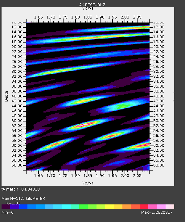
| Estimated Moho Depth: |
51.5 km |
| Estimated Crust Vp/Vs: |
1.83 |
| Assumed Crust Vp: |
6.566 km/s |
| Estimated Crust Vs: |
3.588 km/s |
| Estimated Crust Poisson's Ratio: |
0.29 |
|
| Radial Match: |
84.04338 % |
| Radial Bump: |
400 |
| Transverse Match: |
76.22019 % |
| Transverse Bump: |
400 |
| SOD ConfigId: |
30536071 |
| Insert Time: |
2023-03-28 00:50:12.294 +0000 |
| GWidth: |
2.5 |
| Max Bumps: |
400 |
| Tol: |
0.001 |
|

Signal To Noise
| Channel | StoN | STA | LTA |
| AK:BESE: :BHZ:20230314T01:01:05.407982Z | 20.810312 | 3.1315892E-6 | 1.5048256E-7 |
| AK:BESE: :BHN:20230314T01:01:05.407982Z | 2.3841379 | 3.603132E-7 | 1.5112934E-7 |
| AK:BESE: :BHE:20230314T01:01:05.407982Z | 7.940502 | 1.3832811E-6 | 1.7420575E-7 |
| Arrivals |
| Ps | 6.7 SECOND |
| PpPs | 22 SECOND |
| PsPs/PpSs | 28 SECOND |


