You are here: Home > Network List > AK - Alaska Regional Network Stations List
> Station I27K Kandik River, AK, USA > Earthquake Result Viewer
I27K Kandik River, AK, USA - Earthquake Result Viewer
| Earthquake location: |
Eastern New Guinea Reg., P.N.G. |
| Earthquake latitude/longitude: |
-5.4/146.9 |
| Earthquake time(UTC): |
2023/03/14 (073) 00:49:08 GMT |
| Earthquake Depth: |
213 km |
| Earthquake Magnitude: |
6.3 mww |
| Earthquake Catalog/Contributor: |
NEIC PDE/us |
|
| Network: |
AK Alaska Regional Network |
| Station: |
I27K Kandik River, AK, USA |
| Lat/Lon: |
65.60 N/141.62 W |
| Elevation: |
874 m |
|
| Distance: |
87.4 deg |
| Az: |
23.227 deg |
| Baz: |
250.966 deg |
| Ray Param: |
0.042875353 |
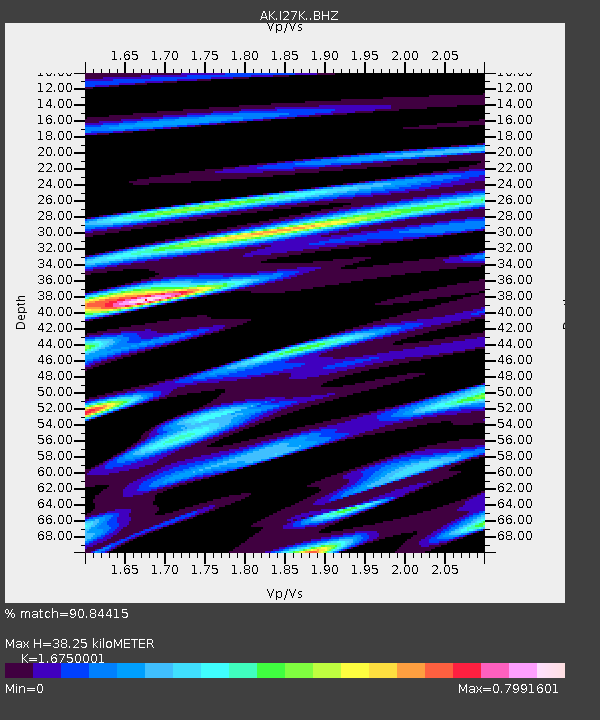
| Estimated Moho Depth: |
38.25 km |
| Estimated Crust Vp/Vs: |
1.68 |
| Assumed Crust Vp: |
6.566 km/s |
| Estimated Crust Vs: |
3.92 km/s |
| Estimated Crust Poisson's Ratio: |
0.22 |
|
| Radial Match: |
90.84415 % |
| Radial Bump: |
336 |
| Transverse Match: |
84.2575 % |
| Transverse Bump: |
362 |
| SOD ConfigId: |
30536071 |
| Insert Time: |
2023-03-28 00:51:43.789 +0000 |
| GWidth: |
2.5 |
| Max Bumps: |
400 |
| Tol: |
0.001 |
|

Signal To Noise
| Channel | StoN | STA | LTA |
| AK:I27K: :BHZ:20230314T01:01:00.079979Z | 24.237028 | 3.4809996E-6 | 1.4362321E-7 |
| AK:I27K: :BHN:20230314T01:01:00.079979Z | 6.388114 | 6.5534994E-7 | 1.0258895E-7 |
| AK:I27K: :BHE:20230314T01:01:00.079979Z | 11.6343565 | 1.3602105E-6 | 1.16913256E-7 |
| Arrivals |
| Ps | 4.0 SECOND |
| PpPs | 15 SECOND |
| PsPs/PpSs | 19 SECOND |


