You are here: Home > Network List > AK - Alaska Regional Network Stations List
> Station K13K Kusilvak Mountain, AK, USA > Earthquake Result Viewer
K13K Kusilvak Mountain, AK, USA - Earthquake Result Viewer
| Earthquake location: |
Eastern New Guinea Reg., P.N.G. |
| Earthquake latitude/longitude: |
-5.4/146.9 |
| Earthquake time(UTC): |
2023/03/14 (073) 00:49:08 GMT |
| Earthquake Depth: |
213 km |
| Earthquake Magnitude: |
6.3 mww |
| Earthquake Catalog/Contributor: |
NEIC PDE/us |
|
| Network: |
AK Alaska Regional Network |
| Station: |
K13K Kusilvak Mountain, AK, USA |
| Lat/Lon: |
61.93 N/164.66 W |
| Elevation: |
204 m |
|
| Distance: |
76.7 deg |
| Az: |
21.34 deg |
| Baz: |
229.999 deg |
| Ray Param: |
0.050257232 |
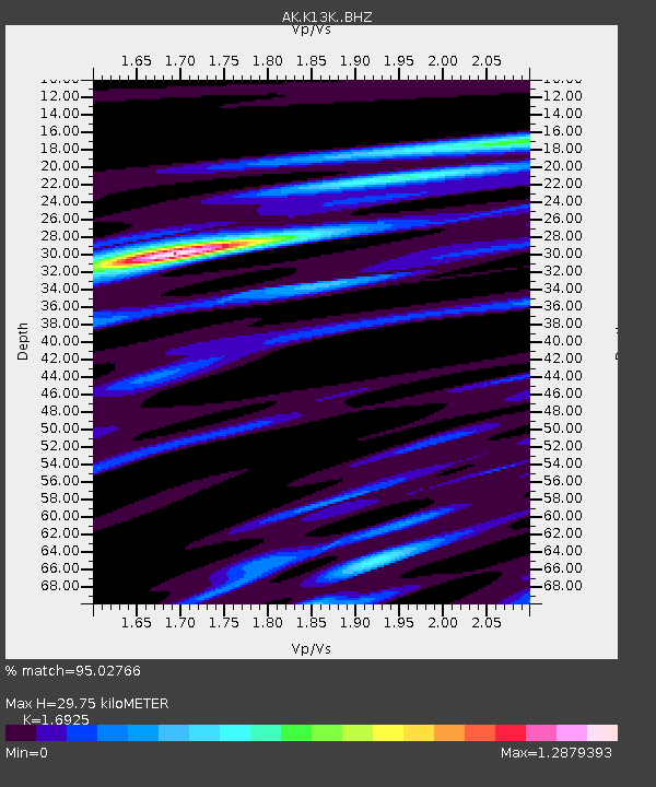
| Estimated Moho Depth: |
29.75 km |
| Estimated Crust Vp/Vs: |
1.69 |
| Assumed Crust Vp: |
6.1 km/s |
| Estimated Crust Vs: |
3.604 km/s |
| Estimated Crust Poisson's Ratio: |
0.23 |
|
| Radial Match: |
95.02766 % |
| Radial Bump: |
248 |
| Transverse Match: |
87.1909 % |
| Transverse Bump: |
400 |
| SOD ConfigId: |
30536071 |
| Insert Time: |
2023-03-28 00:51:54.247 +0000 |
| GWidth: |
2.5 |
| Max Bumps: |
400 |
| Tol: |
0.001 |
|

Signal To Noise
| Channel | StoN | STA | LTA |
| AK:K13K: :BHZ:20230314T01:00:05.040001Z | 34.424614 | 3.8193916E-6 | 1.10949436E-7 |
| AK:K13K: :BHN:20230314T01:00:05.040001Z | 12.555057 | 1.1316022E-6 | 9.0131195E-8 |
| AK:K13K: :BHE:20230314T01:00:05.040001Z | 15.153252 | 1.1451168E-6 | 7.556905E-8 |
| Arrivals |
| Ps | 3.5 SECOND |
| PpPs | 13 SECOND |
| PsPs/PpSs | 16 SECOND |


