You are here: Home > Network List > AK - Alaska Regional Network Stations List
> Station L17K Donlin, AK, USA > Earthquake Result Viewer
L17K Donlin, AK, USA - Earthquake Result Viewer
| Earthquake location: |
Eastern New Guinea Reg., P.N.G. |
| Earthquake latitude/longitude: |
-5.4/146.9 |
| Earthquake time(UTC): |
2023/03/14 (073) 00:49:08 GMT |
| Earthquake Depth: |
213 km |
| Earthquake Magnitude: |
6.3 mww |
| Earthquake Catalog/Contributor: |
NEIC PDE/us |
|
| Network: |
AK Alaska Regional Network |
| Station: |
L17K Donlin, AK, USA |
| Lat/Lon: |
62.13 N/158.30 W |
| Elevation: |
338 m |
|
| Distance: |
79.2 deg |
| Az: |
23.02 deg |
| Baz: |
235.957 deg |
| Ray Param: |
0.04856414 |
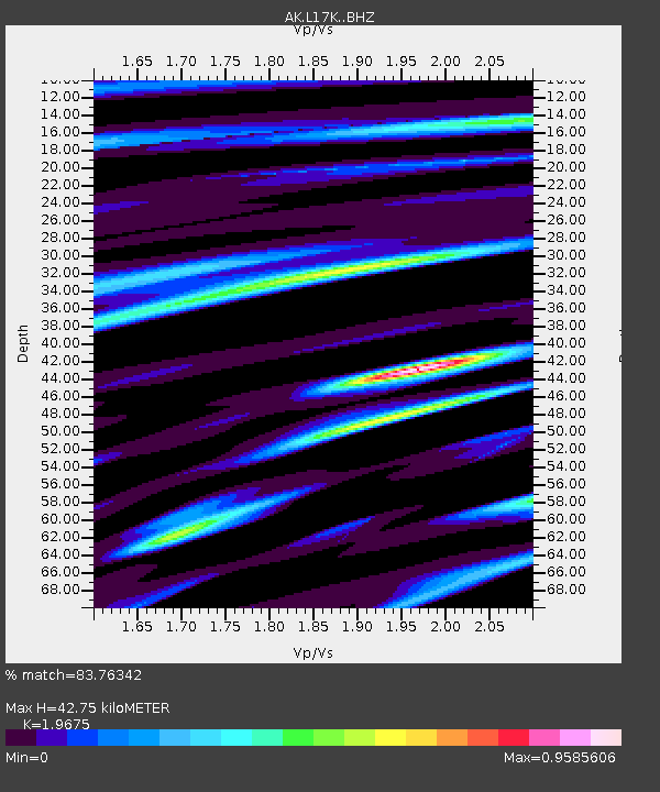
| Estimated Moho Depth: |
42.75 km |
| Estimated Crust Vp/Vs: |
1.97 |
| Assumed Crust Vp: |
6.276 km/s |
| Estimated Crust Vs: |
3.19 km/s |
| Estimated Crust Poisson's Ratio: |
0.33 |
|
| Radial Match: |
83.76342 % |
| Radial Bump: |
292 |
| Transverse Match: |
84.805695 % |
| Transverse Bump: |
400 |
| SOD ConfigId: |
30536071 |
| Insert Time: |
2023-03-28 00:52:07.077 +0000 |
| GWidth: |
2.5 |
| Max Bumps: |
400 |
| Tol: |
0.001 |
|

Signal To Noise
| Channel | StoN | STA | LTA |
| AK:L17K: :BHZ:20230314T01:00:18.800011Z | 21.669205 | 3.590145E-6 | 1.656796E-7 |
| AK:L17K: :BHN:20230314T01:00:18.800011Z | 7.0255556 | 8.273365E-7 | 1.1776101E-7 |
| AK:L17K: :BHE:20230314T01:00:18.800011Z | 9.790568 | 1.2231184E-6 | 1.2492822E-7 |
| Arrivals |
| Ps | 6.8 SECOND |
| PpPs | 20 SECOND |
| PsPs/PpSs | 26 SECOND |


