You are here: Home > Network List > TA - USArray Transportable Network (new EarthScope stations) Stations List
> Station D24A Glendive, MT, USA > Earthquake Result Viewer
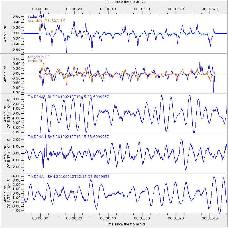
D24A Glendive, MT, USA - Earthquake Result Viewer
*The percent match for this event was below the threshold and hence no stack was calculated.
| Earthquake location: |
Mendoza Province, Argentina |
| Earthquake latitude/longitude: |
-33.6/-68.8 |
| Earthquake time(UTC): |
2010/02/12 (043) 12:03:38 GMT |
| Earthquake Depth: |
148 km |
| Earthquake Magnitude: |
5.6 MB, 5.8 MW, 5.8 MW |
| Earthquake Catalog/Contributor: |
WHDF/NEIC |
|
| Network: |
TA USArray Transportable Network (new EarthScope stations) |
| Station: |
D24A Glendive, MT, USA |
| Lat/Lon: |
47.12 N/104.33 W |
| Elevation: |
766 m |
|
| Distance: |
86.5 deg |
| Az: |
336.564 deg |
| Baz: |
150.928 deg |
| Ray Param: |
$rayparam |
*The percent match for this event was below the threshold and hence was not used in the summary stack. |
|
| Radial Match: |
54.868088 % |
| Radial Bump: |
319 |
| Transverse Match: |
60.32896 % |
| Transverse Bump: |
400 |
| SOD ConfigId: |
306082 |
| Insert Time: |
2010-05-06 06:49:36.680 +0000 |
| GWidth: |
2.5 |
| Max Bumps: |
400 |
| Tol: |
0.001 |
|
Signal To Noise
| Channel | StoN | STA | LTA |
| TA:D24A: :BHZ:20100212T12:15:33.699995Z | 1.8497133 | 1.1024854E-6 | 5.960304E-7 |
| TA:D24A: :BHN:20100212T12:15:33.699995Z | 1.1150475 | 1.1396309E-6 | 1.022047E-6 |
| TA:D24A: :BHE:20100212T12:15:33.699995Z | 0.8786416 | 1.9890274E-6 | 2.2637528E-6 |
| Arrivals |
| Ps | |
| PpPs | |
| PsPs/PpSs | |


