You are here: Home > Network List > TA - USArray Transportable Network (new EarthScope stations) Stations List
> Station Z29A Hungry Hill Ranch, Wilson, TX, USA > Earthquake Result Viewer
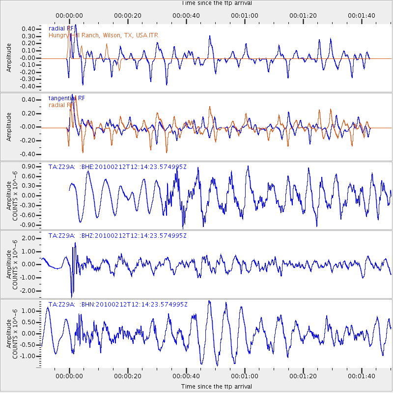
Z29A Hungry Hill Ranch, Wilson, TX, USA - Earthquake Result Viewer
*The percent match for this event was below the threshold and hence no stack was calculated.
| Earthquake location: |
Mendoza Province, Argentina |
| Earthquake latitude/longitude: |
-33.6/-68.8 |
| Earthquake time(UTC): |
2010/02/12 (043) 12:03:38 GMT |
| Earthquake Depth: |
148 km |
| Earthquake Magnitude: |
5.6 MB, 5.8 MW, 5.8 MW |
| Earthquake Catalog/Contributor: |
WHDF/NEIC |
|
| Network: |
TA USArray Transportable Network (new EarthScope stations) |
| Station: |
Z29A Hungry Hill Ranch, Wilson, TX, USA |
| Lat/Lon: |
33.26 N/101.71 W |
| Elevation: |
938 m |
|
| Distance: |
73.4 deg |
| Az: |
331.629 deg |
| Baz: |
151.757 deg |
| Ray Param: |
$rayparam |
*The percent match for this event was below the threshold and hence was not used in the summary stack. |
|
| Radial Match: |
55.17614 % |
| Radial Bump: |
388 |
| Transverse Match: |
73.0068 % |
| Transverse Bump: |
400 |
| SOD ConfigId: |
306082 |
| Insert Time: |
2010-05-06 06:53:07.648 +0000 |
| GWidth: |
2.5 |
| Max Bumps: |
400 |
| Tol: |
0.001 |
|
Signal To Noise
| Channel | StoN | STA | LTA |
| TA:Z29A: :BHZ:20100212T12:14:23.574995Z | 2.4009342 | 8.8862737E-7 | 3.7011733E-7 |
| TA:Z29A: :BHN:20100212T12:14:23.574995Z | 0.81923926 | 4.9351564E-7 | 6.024072E-7 |
| TA:Z29A: :BHE:20100212T12:14:23.574995Z | 0.8571246 | 3.3013436E-7 | 3.8516492E-7 |
| Arrivals |
| Ps | |
| PpPs | |
| PsPs/PpSs | |


