You are here: Home > Network List > US - United States National Seismic Network Stations List
> Station MSO Missoula, Montana, USA > Earthquake Result Viewer
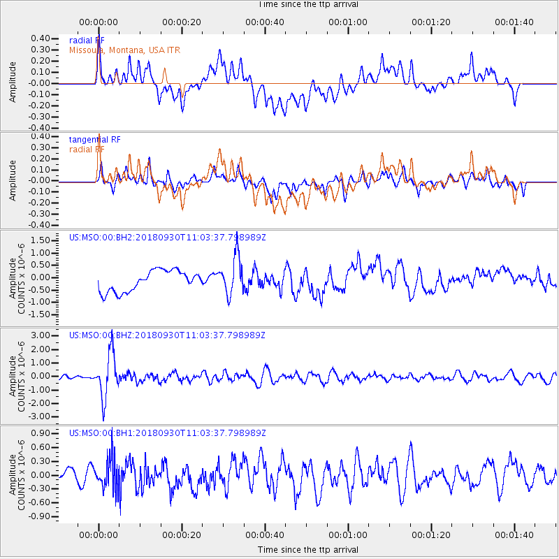
MSO Missoula, Montana, USA - Earthquake Result Viewer
*The percent match for this event was below the threshold and hence no stack was calculated.
| Earthquake location: |
Fiji Islands Region |
| Earthquake latitude/longitude: |
-18.4/-178.1 |
| Earthquake time(UTC): |
2018/09/30 (273) 10:52:23 GMT |
| Earthquake Depth: |
551 km |
| Earthquake Magnitude: |
6.6 mww |
| Earthquake Catalog/Contributor: |
NEIC PDE/us |
|
| Network: |
US United States National Seismic Network |
| Station: |
MSO Missoula, Montana, USA |
| Lat/Lon: |
46.83 N/113.94 W |
| Elevation: |
1264 m |
|
| Distance: |
86.8 deg |
| Az: |
38.238 deg |
| Baz: |
238.874 deg |
| Ray Param: |
$rayparam |
*The percent match for this event was below the threshold and hence was not used in the summary stack. |
|
| Radial Match: |
47.19077 % |
| Radial Bump: |
400 |
| Transverse Match: |
67.35307 % |
| Transverse Bump: |
400 |
| SOD ConfigId: |
3045211 |
| Insert Time: |
2018-10-14 11:12:55.460 +0000 |
| GWidth: |
2.5 |
| Max Bumps: |
400 |
| Tol: |
0.001 |
|
Signal To Noise
| Channel | StoN | STA | LTA |
| US:MSO:00:BHZ:20180930T11:03:37.798989Z | 14.158147 | 1.6429327E-6 | 1.1604151E-7 |
| US:MSO:00:BH1:20180930T11:03:37.798989Z | 2.1175537 | 3.4099196E-7 | 1.6103108E-7 |
| US:MSO:00:BH2:20180930T11:03:37.798989Z | 1.8979338 | 7.9752994E-7 | 4.2020957E-7 |
| Arrivals |
| Ps | |
| PpPs | |
| PsPs/PpSs | |


