You are here: Home > Network List > TA - USArray Transportable Network (new EarthScope stations) Stations List
> Station 231A Bronte, TX, USA > Earthquake Result Viewer
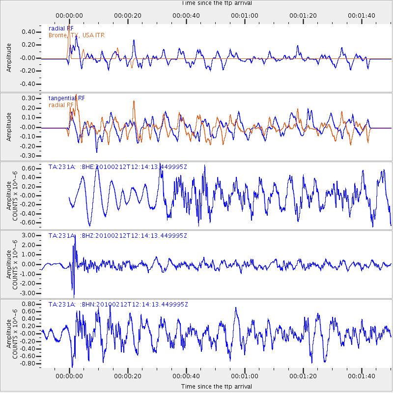
231A Bronte, TX, USA - Earthquake Result Viewer
*The percent match for this event was below the threshold and hence no stack was calculated.
| Earthquake location: |
Mendoza Province, Argentina |
| Earthquake latitude/longitude: |
-33.6/-68.8 |
| Earthquake time(UTC): |
2010/02/12 (043) 12:03:38 GMT |
| Earthquake Depth: |
148 km |
| Earthquake Magnitude: |
5.6 MB, 5.8 MW, 5.8 MW |
| Earthquake Catalog/Contributor: |
WHDF/NEIC |
|
| Network: |
TA USArray Transportable Network (new EarthScope stations) |
| Station: |
231A Bronte, TX, USA |
| Lat/Lon: |
31.94 N/100.32 W |
| Elevation: |
574 m |
|
| Distance: |
71.7 deg |
| Az: |
332.071 deg |
| Baz: |
152.635 deg |
| Ray Param: |
$rayparam |
*The percent match for this event was below the threshold and hence was not used in the summary stack. |
|
| Radial Match: |
64.03028 % |
| Radial Bump: |
400 |
| Transverse Match: |
60.64945 % |
| Transverse Bump: |
400 |
| SOD ConfigId: |
306082 |
| Insert Time: |
2010-05-06 06:55:36.493 +0000 |
| GWidth: |
2.5 |
| Max Bumps: |
400 |
| Tol: |
0.001 |
|
Signal To Noise
| Channel | StoN | STA | LTA |
| TA:231A: :BHZ:20100212T12:14:13.449995Z | 3.3033445 | 1.0934514E-6 | 3.3101344E-7 |
| TA:231A: :BHN:20100212T12:14:13.449995Z | 2.068161 | 3.9098074E-7 | 1.8904754E-7 |
| TA:231A: :BHE:20100212T12:14:13.449995Z | 1.2922584 | 3.6058657E-7 | 2.7903596E-7 |
| Arrivals |
| Ps | |
| PpPs | |
| PsPs/PpSs | |


