You are here: Home > Network List > TM - Thai Seismic Monitoring Network Stations List
> Station SRIT Phipun, Nakhon Si Thammarat > Earthquake Result Viewer
SRIT Phipun, Nakhon Si Thammarat - Earthquake Result Viewer
| Earthquake location: |
Eastern New Guinea Reg., P.N.G. |
| Earthquake latitude/longitude: |
-5.4/146.9 |
| Earthquake time(UTC): |
2023/03/14 (073) 00:49:08 GMT |
| Earthquake Depth: |
213 km |
| Earthquake Magnitude: |
6.3 mww |
| Earthquake Catalog/Contributor: |
NEIC PDE/us |
|
| Network: |
TM Thai Seismic Monitoring Network |
| Station: |
SRIT Phipun, Nakhon Si Thammarat |
| Lat/Lon: |
8.60 N/99.60 E |
| Elevation: |
77 m |
|
| Distance: |
49.1 deg |
| Az: |
286.176 deg |
| Baz: |
104.779 deg |
| Ray Param: |
0.06811956 |
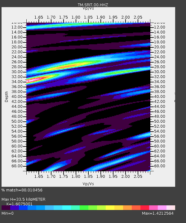
| Estimated Moho Depth: |
33.5 km |
| Estimated Crust Vp/Vs: |
1.61 |
| Assumed Crust Vp: |
6.468 km/s |
| Estimated Crust Vs: |
4.023 km/s |
| Estimated Crust Poisson's Ratio: |
0.18 |
|
| Radial Match: |
88.018456 % |
| Radial Bump: |
400 |
| Transverse Match: |
77.38434 % |
| Transverse Bump: |
400 |
| SOD ConfigId: |
30536071 |
| Insert Time: |
2023-03-28 01:08:59.698 +0000 |
| GWidth: |
2.5 |
| Max Bumps: |
400 |
| Tol: |
0.001 |
|

Signal To Noise
| Channel | StoN | STA | LTA |
| TM:SRIT:00:HHZ:20230314T00:57:03.80999Z | 4.186916 | 4.7283388E-7 | 1.129313E-7 |
| TM:SRIT:00:HHN:20230314T00:57:03.80999Z | 1.0647438 | 2.1603378E-7 | 2.0289745E-7 |
| TM:SRIT:00:HHE:20230314T00:57:03.80999Z | 1.5736592 | 2.866452E-7 | 1.8215202E-7 |
| Arrivals |
| Ps | 3.4 SECOND |
| PpPs | 13 SECOND |
| PsPs/PpSs | 16 SECOND |


