You are here: Home > Network List > UW - Pacific Northwest Regional Seismic Network Stations List
> Station HOOD Mt Hood Meadows, OR CREST BB SMO > Earthquake Result Viewer
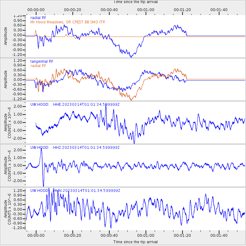
HOOD Mt Hood Meadows, OR CREST BB SMO - Earthquake Result Viewer
*The percent match for this event was below the threshold and hence no stack was calculated.
| Earthquake location: |
Eastern New Guinea Reg., P.N.G. |
| Earthquake latitude/longitude: |
-5.4/146.9 |
| Earthquake time(UTC): |
2023/03/14 (073) 00:49:08 GMT |
| Earthquake Depth: |
213 km |
| Earthquake Magnitude: |
6.3 mww |
| Earthquake Catalog/Contributor: |
NEIC PDE/us |
|
| Network: |
UW Pacific Northwest Regional Seismic Network |
| Station: |
HOOD Mt Hood Meadows, OR CREST BB SMO |
| Lat/Lon: |
45.32 N/121.65 W |
| Elevation: |
1520 m |
|
| Distance: |
94.9 deg |
| Az: |
45.057 deg |
| Baz: |
267.259 deg |
| Ray Param: |
$rayparam |
*The percent match for this event was below the threshold and hence was not used in the summary stack. |
|
| Radial Match: |
67.73787 % |
| Radial Bump: |
400 |
| Transverse Match: |
58.778553 % |
| Transverse Bump: |
400 |
| SOD ConfigId: |
30536071 |
| Insert Time: |
2023-03-28 01:12:08.923 +0000 |
| GWidth: |
2.5 |
| Max Bumps: |
400 |
| Tol: |
0.001 |
|
Signal To Noise
| Channel | StoN | STA | LTA |
| UW:HOOD: :HHZ:20230314T01:01:34.599999Z | 8.0752945 | 1.1613383E-6 | 1.4381374E-7 |
| UW:HOOD: :HHN:20230314T01:01:34.599999Z | 0.38185835 | 3.259724E-7 | 8.536474E-7 |
| UW:HOOD: :HHE:20230314T01:01:34.599999Z | 1.0009931 | 8.2123944E-7 | 8.2042465E-7 |
| Arrivals |
| Ps | |
| PpPs | |
| PsPs/PpSs | |


