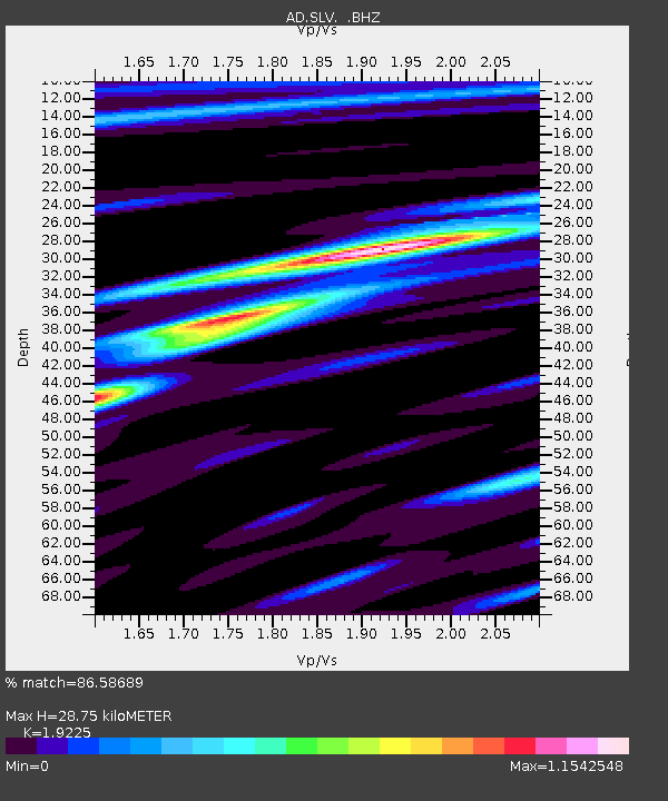
SLV Son La Vietnam - Earthquake Result Viewer

Earthquake location: Tonga Islands
Earthquake latitude/longitude: -21.9/-174.8
Earthquake time(UTC): 2010/02/13 (044) 02:34:28 GMT
Earthquake Depth: 11 km
Earthquake Magnitude: 6.0 MB, 6.2 MS, 6.1 MW, 6.0 MW
Earthquake Catalog/Contributor: WHDF/NEIC
Network: AD Asian Disaster Preparedness Center- Early Warning Center
Station: SLV Son La Vietnam
Lat/Lon: 21.33 N/103.90 E
Elevation: 50 m
Distance: 90.2 deg
Az: 292.832 deg
Baz: 113.354 deg
Ray Param: 0.041689776
Estimated Moho Depth: 28.75 km
Estimated Crust Vp/Vs: 1.92
Assumed Crust Vp: 6.35 km/s
Estimated Crust Vs: 3.303 km/s
Estimated Crust Poisson's Ratio: 0.31
Radial Match: 86.58689 %
Radial Bump: 400
Transverse Match: 78.81553 %
Transverse Bump: 400
SOD ConfigId: 306082
Insert Time: 2010-05-06 07:09:49.327 +0000
GWidth: 2.5
Max Bumps: 400
Tol: 0.001

Signal To Noise

ChannelStoNSTALTA
AD:SLV: :BHZ:20100213T02:46:57.669998Z3.53887584.6437933E-71.3122228E-7
AD:SLV: :BHN:20100213T02:46:57.669998Z1.15947889.994181E-88.6195456E-8
AD:SLV: :BHE:20100213T02:46:57.669998Z1.30803331.15784886E-78.85183E-8
Arrivals
Ps4.3 SECOND
PpPs13 SECOND
PsPs/PpSs17 SECOND