You are here: Home > Network List > AE - Arizona Broadband Seismic Network Stations List
> Station LOGN Mt. Logan, AZ, USA > Earthquake Result Viewer
LOGN Mt. Logan, AZ, USA - Earthquake Result Viewer
| Earthquake location: |
Kermadec Islands Region |
| Earthquake latitude/longitude: |
-30.2/-175.9 |
| Earthquake time(UTC): |
2023/03/16 (075) 00:55:58 GMT |
| Earthquake Depth: |
10 km |
| Earthquake Magnitude: |
7.1 Mi |
| Earthquake Catalog/Contributor: |
NEIC PDE/pt |
|
| Network: |
AE Arizona Broadband Seismic Network |
| Station: |
LOGN Mt. Logan, AZ, USA |
| Lat/Lon: |
36.35 N/113.20 W |
| Elevation: |
2309 m |
|
| Distance: |
88.6 deg |
| Az: |
45.83 deg |
| Baz: |
230.261 deg |
| Ray Param: |
0.04250277 |
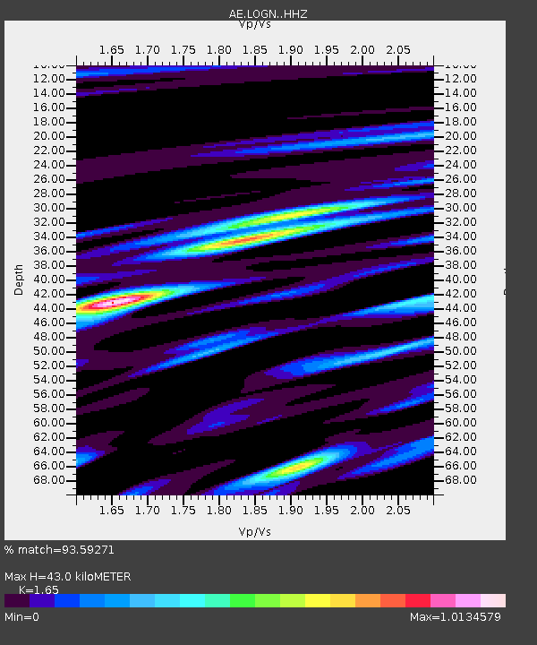
| Estimated Moho Depth: |
43.0 km |
| Estimated Crust Vp/Vs: |
1.65 |
| Assumed Crust Vp: |
6.194 km/s |
| Estimated Crust Vs: |
3.754 km/s |
| Estimated Crust Poisson's Ratio: |
0.21 |
|
| Radial Match: |
93.59271 % |
| Radial Bump: |
400 |
| Transverse Match: |
88.188545 % |
| Transverse Bump: |
400 |
| SOD ConfigId: |
30536071 |
| Insert Time: |
2023-03-30 00:56:56.801 +0000 |
| GWidth: |
2.5 |
| Max Bumps: |
400 |
| Tol: |
0.001 |
|

Signal To Noise
| Channel | StoN | STA | LTA |
| AE:LOGN: :HHZ:20230316T01:08:19.26001Z | 1.913932 | 3.6334836E-7 | 1.8984392E-7 |
| AE:LOGN: :HHN:20230316T01:08:19.26001Z | 0.815571 | 2.5217466E-7 | 3.0920015E-7 |
| AE:LOGN: :HHE:20230316T01:08:19.26001Z | 1.7116891 | 6.012689E-7 | 3.5127226E-7 |
| Arrivals |
| Ps | 4.6 SECOND |
| PpPs | 18 SECOND |
| PsPs/PpSs | 23 SECOND |


