You are here: Home > Network List > AV - Alaska Volcano Observatory Stations List
> Station AMKA Regional Station, Amchitka Island, Alaska > Earthquake Result Viewer
AMKA Regional Station, Amchitka Island, Alaska - Earthquake Result Viewer
| Earthquake location: |
Kermadec Islands Region |
| Earthquake latitude/longitude: |
-30.2/-175.9 |
| Earthquake time(UTC): |
2023/03/16 (075) 00:55:58 GMT |
| Earthquake Depth: |
10 km |
| Earthquake Magnitude: |
7.1 Mi |
| Earthquake Catalog/Contributor: |
NEIC PDE/pt |
|
| Network: |
AV Alaska Volcano Observatory |
| Station: |
AMKA Regional Station, Amchitka Island, Alaska |
| Lat/Lon: |
51.38 N/179.30 E |
| Elevation: |
116 m |
|
| Distance: |
81.4 deg |
| Az: |
356.929 deg |
| Baz: |
175.757 deg |
| Ray Param: |
0.047642235 |
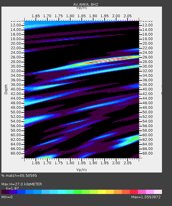
| Estimated Moho Depth: |
27.0 km |
| Estimated Crust Vp/Vs: |
1.97 |
| Assumed Crust Vp: |
6.183 km/s |
| Estimated Crust Vs: |
3.138 km/s |
| Estimated Crust Poisson's Ratio: |
0.33 |
|
| Radial Match: |
88.58595 % |
| Radial Bump: |
400 |
| Transverse Match: |
87.84153 % |
| Transverse Bump: |
400 |
| SOD ConfigId: |
30536071 |
| Insert Time: |
2023-03-30 01:00:45.131 +0000 |
| GWidth: |
2.5 |
| Max Bumps: |
400 |
| Tol: |
0.001 |
|
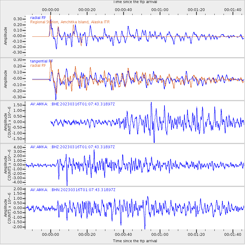
Signal To Noise
| Channel | StoN | STA | LTA |
| AV:AMKA: :BHZ:20230316T01:07:43.31897Z | 5.0454826 | 8.383911E-7 | 1.6616669E-7 |
| AV:AMKA: :BHN:20230316T01:07:43.31897Z | 2.2210495 | 3.171301E-7 | 1.4278389E-7 |
| AV:AMKA: :BHE:20230316T01:07:43.31897Z | 0.85854256 | 1.3380455E-7 | 1.558508E-7 |
| Arrivals |
| Ps | 4.3 SECOND |
| PpPs | 13 SECOND |
| PsPs/PpSs | 17 SECOND |


