You are here: Home > Network List > AV - Alaska Volcano Observatory Stations List
> Station PLK3 Mt. Peulik Volcano 3, Alaska > Earthquake Result Viewer
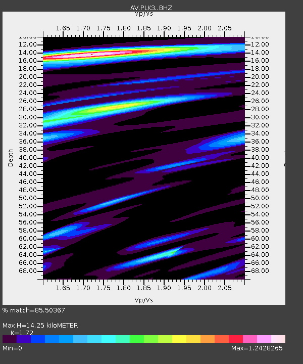
PLK3 Mt. Peulik Volcano 3, Alaska - Earthquake Result Viewer
| Earthquake location: |
Kermadec Islands Region |
| Earthquake latitude/longitude: |
-30.2/-175.9 |
| Earthquake time(UTC): |
2023/03/16 (075) 00:55:58 GMT |
| Earthquake Depth: |
10 km |
| Earthquake Magnitude: |
7.1 Mi |
| Earthquake Catalog/Contributor: |
NEIC PDE/pt |
|
| Network: |
AV Alaska Volcano Observatory |
| Station: |
PLK3 Mt. Peulik Volcano 3, Alaska |
| Lat/Lon: |
57.69 N/156.27 W |
| Elevation: |
494 m |
|
| Distance: |
89.1 deg |
| Az: |
10.371 deg |
| Baz: |
196.862 deg |
| Ray Param: |
0.04208779 |
| Estimated Moho Depth: |
14.25 km |
| Estimated Crust Vp/Vs: |
1.72 |
| Assumed Crust Vp: |
6.1 km/s |
| Estimated Crust Vs: |
3.547 km/s |
| Estimated Crust Poisson's Ratio: |
0.24 |
|
| Radial Match: |
85.50367 % |
| Radial Bump: |
400 |
| Transverse Match: |
68.99608 % |
| Transverse Bump: |
400 |
| SOD ConfigId: |
30536071 |
| Insert Time: |
2023-03-30 01:02:36.046 +0000 |
| GWidth: |
2.5 |
| Max Bumps: |
400 |
| Tol: |
0.001 |
|

Signal To Noise
| Channel | StoN | STA | LTA |
| AV:PLK3: :BHZ:20230316T01:08:21.939026Z | 1.1878449 | 1.6811434E-6 | 1.4152886E-6 |
| AV:PLK3: :BHN:20230316T01:08:21.939026Z | 0.8664362 | 7.0845164E-7 | 8.1766166E-7 |
| AV:PLK3: :BHE:20230316T01:08:21.939026Z | 1.0223832 | 1.0306766E-6 | 1.0081118E-6 |
| Arrivals |
| Ps | 1.7 SECOND |
| PpPs | 6.2 SECOND |
| PsPs/PpSs | 7.9 SECOND |


