You are here: Home > Network List > AV - Alaska Volcano Observatory Stations List
> Station SPCN Ckakachatna North Broadband, Mount Spurr, Alaska > Earthquake Result Viewer
SPCN Ckakachatna North Broadband, Mount Spurr, Alaska - Earthquake Result Viewer
| Earthquake location: |
Kermadec Islands Region |
| Earthquake latitude/longitude: |
-30.2/-175.9 |
| Earthquake time(UTC): |
2023/03/16 (075) 00:55:58 GMT |
| Earthquake Depth: |
10 km |
| Earthquake Magnitude: |
7.1 Mi |
| Earthquake Catalog/Contributor: |
NEIC PDE/pt |
|
| Network: |
AV Alaska Volcano Observatory |
| Station: |
SPCN Ckakachatna North Broadband, Mount Spurr, Alaska |
| Lat/Lon: |
61.22 N/152.19 W |
| Elevation: |
735 m |
|
| Distance: |
93.1 deg |
| Az: |
11.216 deg |
| Baz: |
200.359 deg |
| Ray Param: |
0.041327212 |
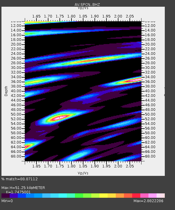
| Estimated Moho Depth: |
51.25 km |
| Estimated Crust Vp/Vs: |
1.75 |
| Assumed Crust Vp: |
6.566 km/s |
| Estimated Crust Vs: |
3.757 km/s |
| Estimated Crust Poisson's Ratio: |
0.26 |
|
| Radial Match: |
88.87112 % |
| Radial Bump: |
400 |
| Transverse Match: |
85.24102 % |
| Transverse Bump: |
400 |
| SOD ConfigId: |
30536071 |
| Insert Time: |
2023-03-30 01:02:54.350 +0000 |
| GWidth: |
2.5 |
| Max Bumps: |
400 |
| Tol: |
0.001 |
|
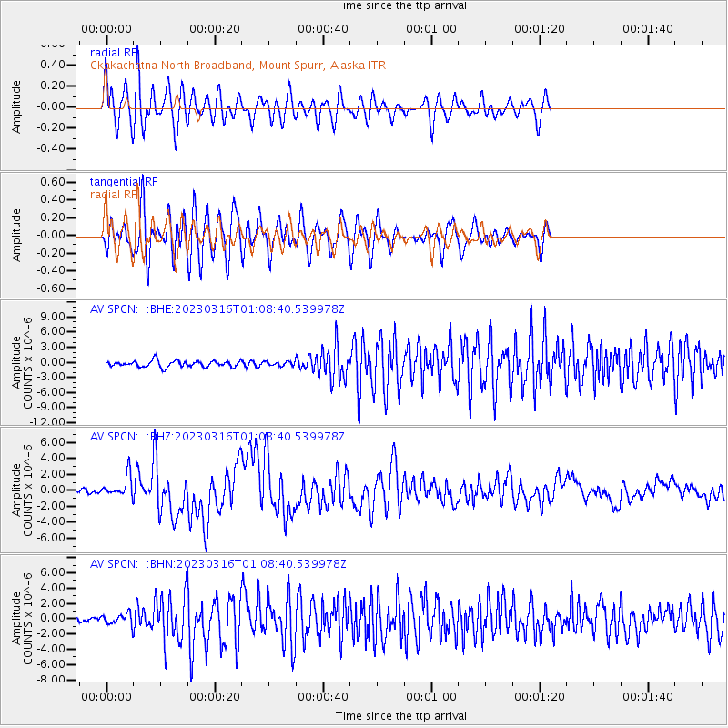
Signal To Noise
| Channel | StoN | STA | LTA |
| AV:SPCN: :BHZ:20230316T01:08:40.539978Z | 6.364976 | 1.3371665E-6 | 2.1008194E-7 |
| AV:SPCN: :BHN:20230316T01:08:40.539978Z | 1.5069733 | 6.6146634E-7 | 4.38937E-7 |
| AV:SPCN: :BHE:20230316T01:08:40.539978Z | 0.678229 | 4.068793E-7 | 5.9991436E-7 |
| Arrivals |
| Ps | 6.0 SECOND |
| PpPs | 21 SECOND |
| PsPs/PpSs | 27 SECOND |


