You are here: Home > Network List > AV - Alaska Volcano Observatory Stations List
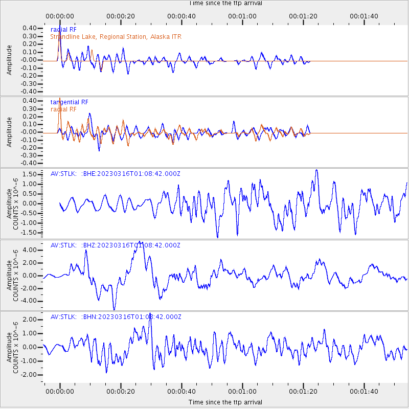
> Station STLK Strandline Lake, Regional Station, Alaska > Earthquake Result Viewer
STLK Strandline Lake, Regional Station, Alaska - Earthquake Result Viewer
| Earthquake location: |
Kermadec Islands Region |
| Earthquake latitude/longitude: |
-30.2/-175.9 |
| Earthquake time(UTC): |
2023/03/16 (075) 00:55:58 GMT |
| Earthquake Depth: |
10 km |
| Earthquake Magnitude: |
7.1 Mi |
| Earthquake Catalog/Contributor: |
NEIC PDE/pt |
|
| Network: |
AV Alaska Volcano Observatory |
| Station: |
STLK Strandline Lake, Regional Station, Alaska |
| Lat/Lon: |
61.50 N/151.83 W |
| Elevation: |
945 m |
|
| Distance: |
93.5 deg |
| Az: |
11.278 deg |
| Baz: |
200.663 deg |
| Ray Param: |
0.041262574 |
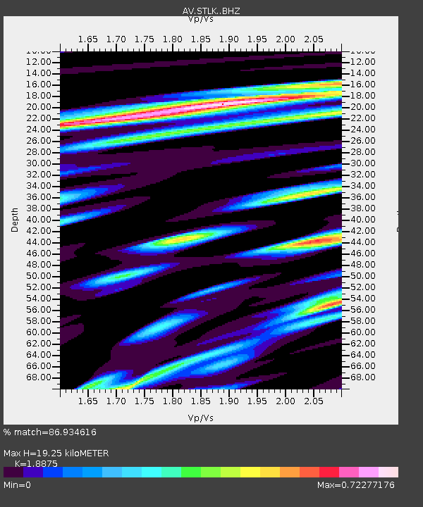
| Estimated Moho Depth: |
19.25 km |
| Estimated Crust Vp/Vs: |
1.89 |
| Assumed Crust Vp: |
6.302 km/s |
| Estimated Crust Vs: |
3.339 km/s |
| Estimated Crust Poisson's Ratio: |
0.30 |
|
| Radial Match: |
86.934616 % |
| Radial Bump: |
400 |
| Transverse Match: |
70.94179 % |
| Transverse Bump: |
400 |
| SOD ConfigId: |
30536071 |
| Insert Time: |
2023-03-30 01:03:02.068 +0000 |
| GWidth: |
2.5 |
| Max Bumps: |
400 |
| Tol: |
0.001 |
|
Signal To Noise
| Channel | StoN | STA | LTA |
| AV:STLK: :BHZ:20230316T01:08:42.000Z | 3.7050056 | 7.433149E-7 | 2.006245E-7 |
| AV:STLK: :BHN:20230316T01:08:42.000Z | 1.359065 | 3.3493913E-7 | 2.4644822E-7 |
| AV:STLK: :BHE:20230316T01:08:42.000Z | 1.5663564 | 3.8860293E-7 | 2.4809356E-7 |
| Arrivals |
| Ps | 2.8 SECOND |
| PpPs | 8.7 SECOND |
| PsPs/PpSs | 11 SECOND |


