You are here: Home > Network List > AV - Alaska Volcano Observatory Stations List
> Station TASE Southeast, Tanaga Volcano, Alaska > Earthquake Result Viewer
TASE Southeast, Tanaga Volcano, Alaska - Earthquake Result Viewer
| Earthquake location: |
Kermadec Islands Region |
| Earthquake latitude/longitude: |
-30.2/-175.9 |
| Earthquake time(UTC): |
2023/03/16 (075) 00:55:58 GMT |
| Earthquake Depth: |
10 km |
| Earthquake Magnitude: |
7.1 Mi |
| Earthquake Catalog/Contributor: |
NEIC PDE/pt |
|
| Network: |
AV Alaska Volcano Observatory |
| Station: |
TASE Southeast, Tanaga Volcano, Alaska |
| Lat/Lon: |
51.83 N/178.04 W |
| Elevation: |
682 m |
|
| Distance: |
81.7 deg |
| Az: |
358.628 deg |
| Baz: |
178.086 deg |
| Ray Param: |
0.047382895 |
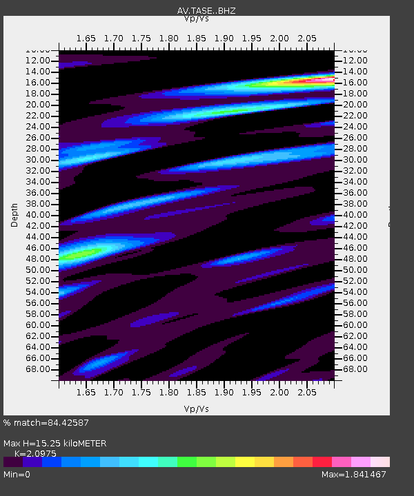
| Estimated Moho Depth: |
15.25 km |
| Estimated Crust Vp/Vs: |
2.10 |
| Assumed Crust Vp: |
6.048 km/s |
| Estimated Crust Vs: |
2.883 km/s |
| Estimated Crust Poisson's Ratio: |
0.35 |
|
| Radial Match: |
84.42587 % |
| Radial Bump: |
400 |
| Transverse Match: |
76.31827 % |
| Transverse Bump: |
400 |
| SOD ConfigId: |
30536071 |
| Insert Time: |
2023-03-30 01:03:07.362 +0000 |
| GWidth: |
2.5 |
| Max Bumps: |
400 |
| Tol: |
0.001 |
|

Signal To Noise
| Channel | StoN | STA | LTA |
| AV:TASE: :BHZ:20230316T01:07:45.26001Z | 3.2592137 | 3.352914E-6 | 1.0287494E-6 |
| AV:TASE: :BHN:20230316T01:07:45.26001Z | 1.8467072 | 2.848028E-6 | 1.5422197E-6 |
| AV:TASE: :BHE:20230316T01:07:45.26001Z | 0.9071532 | 1.3300187E-6 | 1.4661456E-6 |
| Arrivals |
| Ps | 2.8 SECOND |
| PpPs | 7.7 SECOND |
| PsPs/PpSs | 10 SECOND |


