You are here: Home > Network List > BC - Red Sismica del Noroeste de Mexico Stations List
> Station PIX Pinacate, , SON, MEXICO > Earthquake Result Viewer
PIX Pinacate, , SON, MEXICO - Earthquake Result Viewer
| Earthquake location: |
Kermadec Islands Region |
| Earthquake latitude/longitude: |
-30.2/-175.9 |
| Earthquake time(UTC): |
2023/03/16 (075) 00:55:58 GMT |
| Earthquake Depth: |
10 km |
| Earthquake Magnitude: |
7.1 Mi |
| Earthquake Catalog/Contributor: |
NEIC PDE/pt |
|
| Network: |
BC Red Sismica del Noroeste de Mexico |
| Station: |
PIX Pinacate, , SON, MEXICO |
| Lat/Lon: |
31.56 N/113.46 W |
| Elevation: |
78 m |
|
| Distance: |
85.3 deg |
| Az: |
49.371 deg |
| Baz: |
230.305 deg |
| Ray Param: |
0.044843305 |
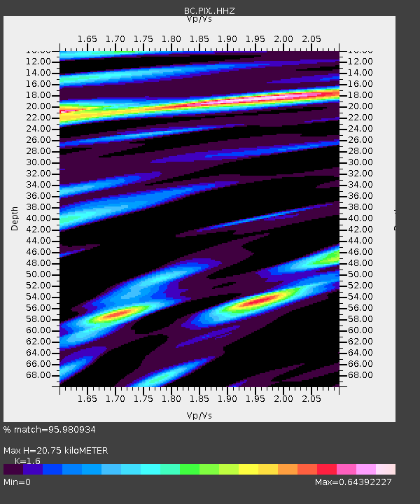
| Estimated Moho Depth: |
20.75 km |
| Estimated Crust Vp/Vs: |
1.60 |
| Assumed Crust Vp: |
6.276 km/s |
| Estimated Crust Vs: |
3.922 km/s |
| Estimated Crust Poisson's Ratio: |
0.18 |
|
| Radial Match: |
95.980934 % |
| Radial Bump: |
324 |
| Transverse Match: |
72.89628 % |
| Transverse Bump: |
400 |
| SOD ConfigId: |
30536071 |
| Insert Time: |
2023-03-30 01:03:35.691 +0000 |
| GWidth: |
2.5 |
| Max Bumps: |
400 |
| Tol: |
0.001 |
|

Signal To Noise
| Channel | StoN | STA | LTA |
| BC:PIX: :HHZ:20230316T01:08:03.640015Z | 1.2881248 | 1.6650978E-7 | 1.2926526E-7 |
| BC:PIX: :HHN:20230316T01:08:03.640015Z | 1.4848989 | 2.0500205E-7 | 1.3805793E-7 |
| BC:PIX: :HHE:20230316T01:08:03.640015Z | 0.90019965 | 1.7053688E-7 | 1.8944338E-7 |
| Arrivals |
| Ps | 2.0 SECOND |
| PpPs | 8.4 SECOND |
| PsPs/PpSs | 10 SECOND |


