You are here: Home > Network List > C8 - Canadian Seismic Research Network () Stations List
> Station KITB Kitimat, BC, CA > Earthquake Result Viewer
KITB Kitimat, BC, CA - Earthquake Result Viewer
| Earthquake location: |
Kermadec Islands Region |
| Earthquake latitude/longitude: |
-30.2/-175.9 |
| Earthquake time(UTC): |
2023/03/16 (075) 00:55:58 GMT |
| Earthquake Depth: |
10 km |
| Earthquake Magnitude: |
7.1 Mi |
| Earthquake Catalog/Contributor: |
NEIC PDE/pt |
|
| Network: |
C8 Canadian Seismic Research Network () |
| Station: |
KITB Kitimat, BC, CA |
| Lat/Lon: |
54.08 N/128.64 W |
| Elevation: |
72 m |
|
| Distance: |
93.3 deg |
| Az: |
25.67 deg |
| Baz: |
219.511 deg |
| Ray Param: |
0.04128703 |
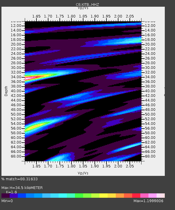
| Estimated Moho Depth: |
34.5 km |
| Estimated Crust Vp/Vs: |
1.60 |
| Assumed Crust Vp: |
6.438 km/s |
| Estimated Crust Vs: |
4.024 km/s |
| Estimated Crust Poisson's Ratio: |
0.18 |
|
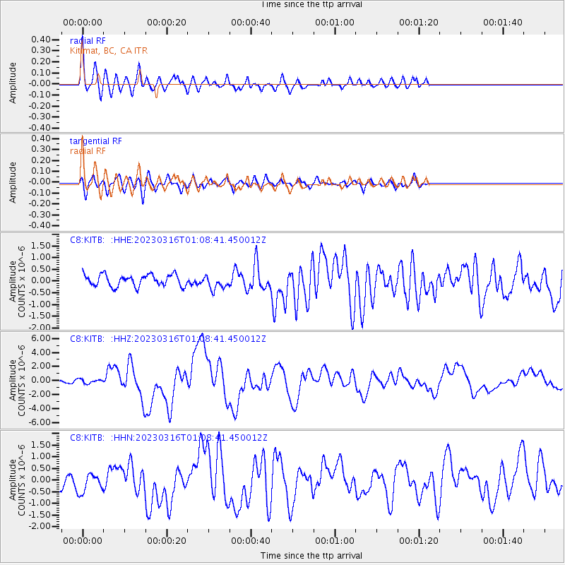
| Radial Match: |
88.31633 % |
| Radial Bump: |
400 |
| Transverse Match: |
60.61943 % |
| Transverse Bump: |
400 |
| SOD ConfigId: |
30536071 |
| Insert Time: |
2023-03-30 01:04:45.017 +0000 |
| GWidth: |
2.5 |
| Max Bumps: |
400 |
| Tol: |
0.001 |
|
Signal To Noise
| Channel | StoN | STA | LTA |
| C8:KITB: :HHZ:20230316T01:08:41.450012Z | 1.3751396 | 2.8165752E-7 | 2.0482103E-7 |
| C8:KITB: :HHN:20230316T01:08:41.450012Z | 1.0040318 | 4.5136048E-7 | 4.49548E-7 |
| C8:KITB: :HHE:20230316T01:08:41.450012Z | 1.2294052 | 3.02326E-7 | 2.4591242E-7 |
| Arrivals |
| Ps | 3.3 SECOND |
| PpPs | 14 SECOND |
| PsPs/PpSs | 17 SECOND |


