You are here: Home > Network List > IU - Global Seismograph Network (GSN - IRIS/USGS) Stations List
> Station CTAO Charters Towers, Australia > Earthquake Result Viewer
CTAO Charters Towers, Australia - Earthquake Result Viewer
| Earthquake location: |
Kermadec Islands Region |
| Earthquake latitude/longitude: |
-30.2/-175.9 |
| Earthquake time(UTC): |
2023/03/16 (075) 00:55:58 GMT |
| Earthquake Depth: |
10 km |
| Earthquake Magnitude: |
7.1 Mi |
| Earthquake Catalog/Contributor: |
NEIC PDE/pt |
|
| Network: |
IU Global Seismograph Network (GSN - IRIS/USGS) |
| Station: |
CTAO Charters Towers, Australia |
| Lat/Lon: |
20.09 S/146.25 E |
| Elevation: |
367 m |
|
| Distance: |
35.6 deg |
| Az: |
277.507 deg |
| Baz: |
114.092 deg |
| Ray Param: |
0.07712874 |
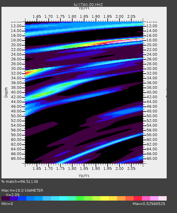
| Estimated Moho Depth: |
18.0 km |
| Estimated Crust Vp/Vs: |
2.05 |
| Assumed Crust Vp: |
6.522 km/s |
| Estimated Crust Vs: |
3.181 km/s |
| Estimated Crust Poisson's Ratio: |
0.34 |
|
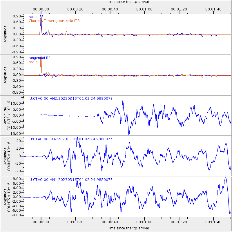
| Radial Match: |
96.51138 % |
| Radial Bump: |
250 |
| Transverse Match: |
72.1089 % |
| Transverse Bump: |
400 |
| SOD ConfigId: |
30536071 |
| Insert Time: |
2023-03-30 01:09:05.850 +0000 |
| GWidth: |
2.5 |
| Max Bumps: |
400 |
| Tol: |
0.001 |
|
Signal To Noise
| Channel | StoN | STA | LTA |
| IU:CTAO:00:HHZ:20230316T01:02:24.988007Z | 6.6518245 | 1.3906723E-6 | 2.090663E-7 |
| IU:CTAO:00:HH1:20230316T01:02:24.988007Z | 1.4080776 | 6.325549E-7 | 4.4923294E-7 |
| IU:CTAO:00:HH2:20230316T01:02:24.988007Z | 2.5752466 | 1.0304641E-6 | 4.001419E-7 |
| Arrivals |
| Ps | 3.1 SECOND |
| PpPs | 7.9 SECOND |
| PsPs/PpSs | 11 SECOND |


