You are here: Home > Network List > JP - Japan Meteorological Agency Seismic Network Stations List
> Station JHJ2 Hachijojima Island > Earthquake Result Viewer
JHJ2 Hachijojima Island - Earthquake Result Viewer
| Earthquake location: |
Kermadec Islands Region |
| Earthquake latitude/longitude: |
-30.2/-175.9 |
| Earthquake time(UTC): |
2023/03/16 (075) 00:55:58 GMT |
| Earthquake Depth: |
10 km |
| Earthquake Magnitude: |
7.1 Mi |
| Earthquake Catalog/Contributor: |
NEIC PDE/pt |
|
| Network: |
JP Japan Meteorological Agency Seismic Network |
| Station: |
JHJ2 Hachijojima Island |
| Lat/Lon: |
33.12 N/139.81 E |
| Elevation: |
70 m |
|
| Distance: |
75.7 deg |
| Az: |
322.75 deg |
| Baz: |
141.377 deg |
| Ray Param: |
0.05150318 |
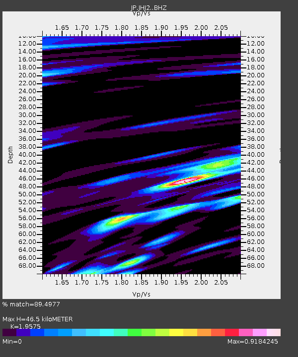
| Estimated Moho Depth: |
46.5 km |
| Estimated Crust Vp/Vs: |
1.96 |
| Assumed Crust Vp: |
4.662 km/s |
| Estimated Crust Vs: |
2.382 km/s |
| Estimated Crust Poisson's Ratio: |
0.32 |
|
| Radial Match: |
89.4977 % |
| Radial Bump: |
400 |
| Transverse Match: |
86.59808 % |
| Transverse Bump: |
400 |
| SOD ConfigId: |
30536071 |
| Insert Time: |
2023-03-30 01:09:30.165 +0000 |
| GWidth: |
2.5 |
| Max Bumps: |
400 |
| Tol: |
0.001 |
|

Signal To Noise
| Channel | StoN | STA | LTA |
| JP:JHJ2: :BHZ:20230316T01:07:12.150024Z | 2.70207 | 4.2153056E-6 | 1.5600282E-6 |
| JP:JHJ2: :BHN:20230316T01:07:12.150024Z | 1.7936032 | 2.7519784E-6 | 1.5343297E-6 |
| JP:JHJ2: :BHE:20230316T01:07:12.150024Z | 1.5211879 | 1.849349E-6 | 1.2157269E-6 |
| Arrivals |
| Ps | 9.7 SECOND |
| PpPs | 29 SECOND |
| PsPs/PpSs | 39 SECOND |


