You are here: Home > Network List > CI - Caltech Regional Seismic Network Stations List
> Station GLA Glamis, Glamis, CA, USA > Earthquake Result Viewer
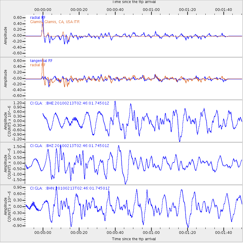
GLA Glamis, Glamis, CA, USA - Earthquake Result Viewer
*The percent match for this event was below the threshold and hence no stack was calculated.
| Earthquake location: |
Tonga Islands |
| Earthquake latitude/longitude: |
-21.9/-174.8 |
| Earthquake time(UTC): |
2010/02/13 (044) 02:34:28 GMT |
| Earthquake Depth: |
11 km |
| Earthquake Magnitude: |
6.0 MB, 6.2 MS, 6.1 MW, 6.0 MW |
| Earthquake Catalog/Contributor: |
WHDF/NEIC |
|
| Network: |
CI Caltech Regional Seismic Network |
| Station: |
GLA Glamis, Glamis, CA, USA |
| Lat/Lon: |
33.05 N/114.83 W |
| Elevation: |
610 m |
|
| Distance: |
79.1 deg |
| Az: |
47.756 deg |
| Baz: |
234.944 deg |
| Ray Param: |
$rayparam |
*The percent match for this event was below the threshold and hence was not used in the summary stack. |
|
| Radial Match: |
66.51861 % |
| Radial Bump: |
373 |
| Transverse Match: |
78.24971 % |
| Transverse Bump: |
378 |
| SOD ConfigId: |
306082 |
| Insert Time: |
2010-05-06 07:15:50.071 +0000 |
| GWidth: |
2.5 |
| Max Bumps: |
400 |
| Tol: |
0.001 |
|
Signal To Noise
| Channel | StoN | STA | LTA |
| CI:GLA: :BHZ:20100213T02:46:01.74501Z | 2.9033043 | 7.0967036E-7 | 2.444354E-7 |
| CI:GLA: :BHN:20100213T02:46:01.74501Z | 2.1170871 | 3.2599675E-7 | 1.5398362E-7 |
| CI:GLA: :BHE:20100213T02:46:01.74501Z | 1.3606299 | 4.1523896E-7 | 3.0518143E-7 |
| Arrivals |
| Ps | |
| PpPs | |
| PsPs/PpSs | |


