You are here: Home > Network List > CI - Caltech Regional Seismic Network Stations List
> Station DAN Danby, California, USA > Earthquake Result Viewer
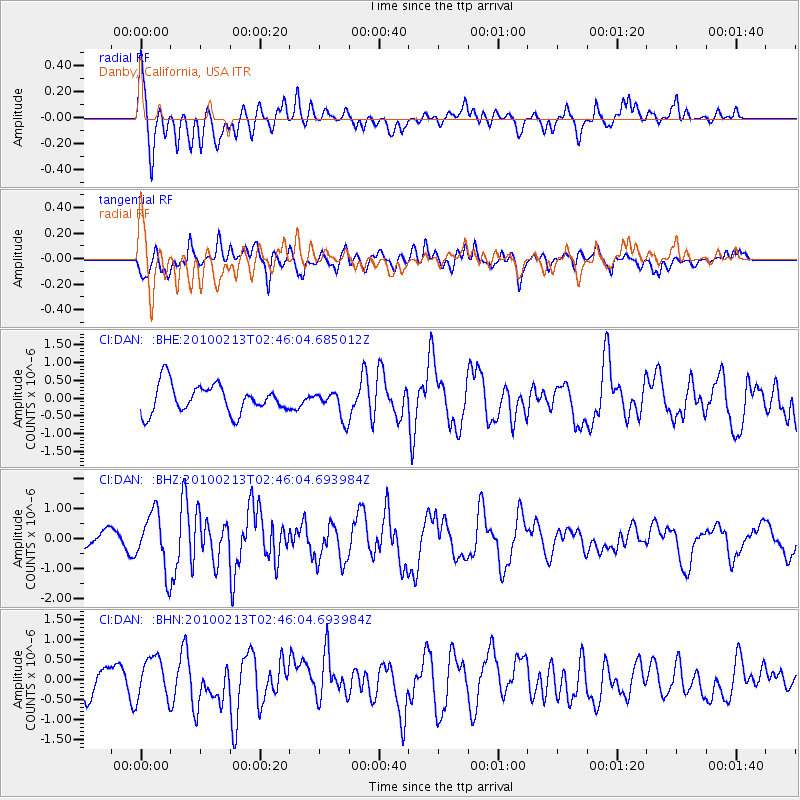
DAN Danby, California, USA - Earthquake Result Viewer
*The percent match for this event was below the threshold and hence no stack was calculated.
| Earthquake location: |
Tonga Islands |
| Earthquake latitude/longitude: |
-21.9/-174.8 |
| Earthquake time(UTC): |
2010/02/13 (044) 02:34:28 GMT |
| Earthquake Depth: |
11 km |
| Earthquake Magnitude: |
6.0 MB, 6.2 MS, 6.1 MW, 6.0 MW |
| Earthquake Catalog/Contributor: |
WHDF/NEIC |
|
| Network: |
CI Caltech Regional Seismic Network |
| Station: |
DAN Danby, California, USA |
| Lat/Lon: |
34.64 N/115.38 W |
| Elevation: |
398 m |
|
| Distance: |
79.6 deg |
| Az: |
46.172 deg |
| Baz: |
234.344 deg |
| Ray Param: |
$rayparam |
*The percent match for this event was below the threshold and hence was not used in the summary stack. |
|
| Radial Match: |
69.94389 % |
| Radial Bump: |
400 |
| Transverse Match: |
59.889675 % |
| Transverse Bump: |
400 |
| SOD ConfigId: |
306082 |
| Insert Time: |
2010-05-06 07:16:25.661 +0000 |
| GWidth: |
2.5 |
| Max Bumps: |
400 |
| Tol: |
0.001 |
|
Signal To Noise
| Channel | StoN | STA | LTA |
| CI:DAN: :BHZ:20100213T02:46:04.693984Z | 4.2706027 | 9.3543014E-7 | 2.1903938E-7 |
| CI:DAN: :BHN:20100213T02:46:04.693984Z | 1.4816738 | 5.182924E-7 | 3.4980195E-7 |
| CI:DAN: :BHE:20100213T02:46:04.685012Z | 0.97290844 | 3.9084364E-7 | 4.0172705E-7 |
| Arrivals |
| Ps | |
| PpPs | |
| PsPs/PpSs | |


