You are here: Home > Network List > 1E - GSC-BCOGC Induced Seismicity Study Stations List
> Station MONT2 Z > Earthquake Result Viewer
MONT2 Z - Earthquake Result Viewer
| Earthquake location: |
Near Coast Of Ecuador |
| Earthquake latitude/longitude: |
-2.9/-79.8 |
| Earthquake time(UTC): |
2023/03/18 (077) 17:12:53 GMT |
| Earthquake Depth: |
66 km |
| Earthquake Magnitude: |
6.7 Mww |
| Earthquake Catalog/Contributor: |
NEIC PDE/us |
|
| Network: |
1E GSC-BCOGC Induced Seismicity Study |
| Station: |
MONT2 Z |
| Lat/Lon: |
56.02 N/120.05 W |
| Elevation: |
642 m |
|
| Distance: |
67.2 deg |
| Az: |
336.83 deg |
| Baz: |
135.583 deg |
| Ray Param: |
0.0569596 |
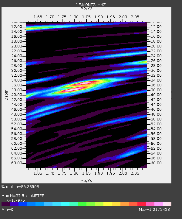
| Estimated Moho Depth: |
37.5 km |
| Estimated Crust Vp/Vs: |
1.80 |
| Assumed Crust Vp: |
6.291 km/s |
| Estimated Crust Vs: |
3.5 km/s |
| Estimated Crust Poisson's Ratio: |
0.28 |
|
| Radial Match: |
85.38598 % |
| Radial Bump: |
400 |
| Transverse Match: |
80.91903 % |
| Transverse Bump: |
400 |
| SOD ConfigId: |
30536071 |
| Insert Time: |
2023-04-01 17:13:29.040 +0000 |
| GWidth: |
2.5 |
| Max Bumps: |
400 |
| Tol: |
0.001 |
|

Signal To Noise
| Channel | StoN | STA | LTA |
| 1E:MONT2: :HHZ:20230318T17:23:09.550001Z | 2.8424144 | 8.2430876E-7 | 2.9000304E-7 |
| 1E:MONT2: :HHN:20230318T17:23:09.550001Z | 1.6682408 | 4.0372925E-7 | 2.4200898E-7 |
| 1E:MONT2: :HHE:20230318T17:23:09.550001Z | 1.042151 | 2.8100126E-7 | 2.6963585E-7 |
| Arrivals |
| Ps | 4.9 SECOND |
| PpPs | 16 SECOND |
| PsPs/PpSs | 21 SECOND |


