You are here: Home > Network List > AG - Arkansas Seismic Network Stations List
> Station XB03 El Dorado Temporary Station XB03 > Earthquake Result Viewer
XB03 El Dorado Temporary Station XB03 - Earthquake Result Viewer
| Earthquake location: |
Near Coast Of Ecuador |
| Earthquake latitude/longitude: |
-2.9/-79.8 |
| Earthquake time(UTC): |
2023/03/18 (077) 17:12:53 GMT |
| Earthquake Depth: |
66 km |
| Earthquake Magnitude: |
6.7 Mww |
| Earthquake Catalog/Contributor: |
NEIC PDE/us |
|
| Network: |
AG Arkansas Seismic Network |
| Station: |
XB03 El Dorado Temporary Station XB03 |
| Lat/Lon: |
36.48 N/90.87 W |
| Elevation: |
144 m |
|
| Distance: |
40.5 deg |
| Az: |
346.209 deg |
| Baz: |
162.817 deg |
| Ray Param: |
0.074190594 |
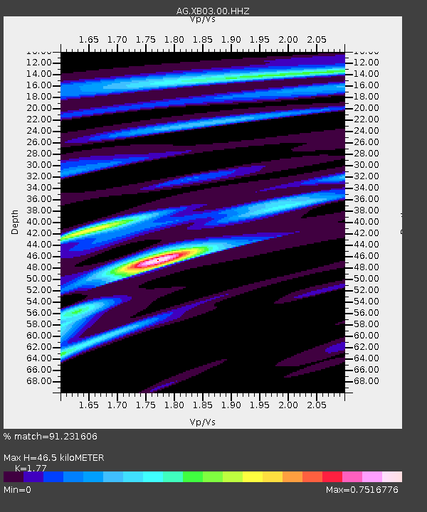
| Estimated Moho Depth: |
46.5 km |
| Estimated Crust Vp/Vs: |
1.77 |
| Assumed Crust Vp: |
6.53 km/s |
| Estimated Crust Vs: |
3.69 km/s |
| Estimated Crust Poisson's Ratio: |
0.27 |
|
| Radial Match: |
91.231606 % |
| Radial Bump: |
224 |
| Transverse Match: |
49.54512 % |
| Transverse Bump: |
367 |
| SOD ConfigId: |
30536071 |
| Insert Time: |
2023-04-01 17:14:43.737 +0000 |
| GWidth: |
2.5 |
| Max Bumps: |
400 |
| Tol: |
0.001 |
|
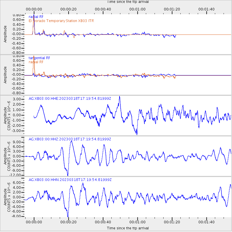
Signal To Noise
| Channel | StoN | STA | LTA |
| AG:XB03:00:HHZ:20230318T17:19:54.81999Z | 4.9492197 | 1.5851724E-6 | 3.2028734E-7 |
| AG:XB03:00:HHN:20230318T17:19:54.81999Z | 2.632859 | 1.171501E-6 | 4.4495397E-7 |
| AG:XB03:00:HHE:20230318T17:19:54.81999Z | 0.67286 | 5.5449976E-7 | 8.240937E-7 |
| Arrivals |
| Ps | 5.9 SECOND |
| PpPs | 18 SECOND |
| PsPs/PpSs | 24 SECOND |


