You are here: Home > Network List > IC - New China Digital Seismograph Network Stations List
> Station BJT Baijiatuan, Beijing, China > Earthquake Result Viewer
BJT Baijiatuan, Beijing, China - Earthquake Result Viewer
| Earthquake location: |
Tonga Islands |
| Earthquake latitude/longitude: |
-21.9/-174.8 |
| Earthquake time(UTC): |
2010/02/13 (044) 02:34:28 GMT |
| Earthquake Depth: |
11 km |
| Earthquake Magnitude: |
6.0 MB, 6.2 MS, 6.1 MW, 6.0 MW |
| Earthquake Catalog/Contributor: |
WHDF/NEIC |
|
| Network: |
IC New China Digital Seismograph Network |
| Station: |
BJT Baijiatuan, Beijing, China |
| Lat/Lon: |
40.02 N/116.17 E |
| Elevation: |
197 m |
|
| Distance: |
89.0 deg |
| Az: |
314.162 deg |
| Baz: |
119.829 deg |
| Ray Param: |
0.04216095 |
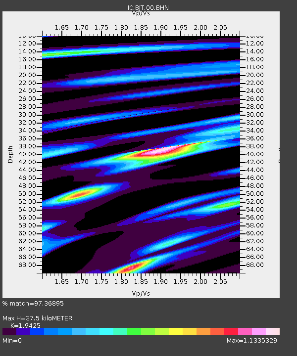
| Estimated Moho Depth: |
37.5 km |
| Estimated Crust Vp/Vs: |
1.94 |
| Assumed Crust Vp: |
6.464 km/s |
| Estimated Crust Vs: |
3.327 km/s |
| Estimated Crust Poisson's Ratio: |
0.32 |
|
| Radial Match: |
97.36895 % |
| Radial Bump: |
313 |
| Transverse Match: |
94.43614 % |
| Transverse Bump: |
400 |
| SOD ConfigId: |
306082 |
| Insert Time: |
2010-05-06 07:18:06.930 +0000 |
| GWidth: |
2.5 |
| Max Bumps: |
400 |
| Tol: |
0.001 |
|
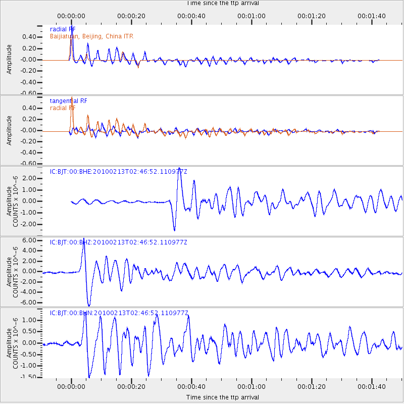
Signal To Noise
| Channel | StoN | STA | LTA |
| IC:BJT:00:BHZ:20100213T02:46:52.110977Z | 24.750668 | 2.2805082E-6 | 9.213925E-8 |
| IC:BJT:00:BHN:20100213T02:46:52.110977Z | 9.093746 | 4.9612333E-7 | 5.4556537E-8 |
| IC:BJT:00:BHE:20100213T02:46:52.110977Z | 8.58081 | 9.141503E-7 | 1.06534266E-7 |
| Arrivals |
| Ps | 5.6 SECOND |
| PpPs | 17 SECOND |
| PsPs/PpSs | 22 SECOND |


