You are here: Home > Network List > AK - Alaska Regional Network Stations List
> Station M16K Timber Creek, AK, USA > Earthquake Result Viewer
M16K Timber Creek, AK, USA - Earthquake Result Viewer
| Earthquake location: |
Near Coast Of Ecuador |
| Earthquake latitude/longitude: |
-2.9/-79.8 |
| Earthquake time(UTC): |
2023/03/18 (077) 17:12:53 GMT |
| Earthquake Depth: |
66 km |
| Earthquake Magnitude: |
6.7 Mww |
| Earthquake Catalog/Contributor: |
NEIC PDE/us |
|
| Network: |
AK Alaska Regional Network |
| Station: |
M16K Timber Creek, AK, USA |
| Lat/Lon: |
61.02 N/158.96 W |
| Elevation: |
394 m |
|
| Distance: |
87.2 deg |
| Az: |
331.391 deg |
| Baz: |
100.857 deg |
| Ray Param: |
0.043354347 |
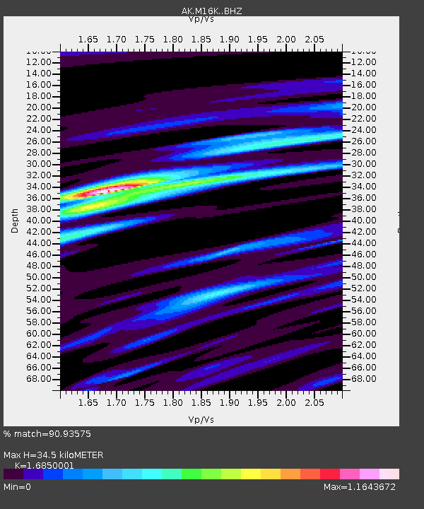
| Estimated Moho Depth: |
34.5 km |
| Estimated Crust Vp/Vs: |
1.69 |
| Assumed Crust Vp: |
6.276 km/s |
| Estimated Crust Vs: |
3.725 km/s |
| Estimated Crust Poisson's Ratio: |
0.23 |
|
| Radial Match: |
90.93575 % |
| Radial Bump: |
332 |
| Transverse Match: |
59.962337 % |
| Transverse Bump: |
400 |
| SOD ConfigId: |
30536071 |
| Insert Time: |
2023-04-01 17:16:52.937 +0000 |
| GWidth: |
2.5 |
| Max Bumps: |
400 |
| Tol: |
0.001 |
|

Signal To Noise
| Channel | StoN | STA | LTA |
| AK:M16K: :BHZ:20230318T17:25:01.039992Z | 3.0444894 | 8.4626004E-7 | 2.7796452E-7 |
| AK:M16K: :BHN:20230318T17:25:01.039992Z | 1.1162162 | 2.3664303E-7 | 2.1200466E-7 |
| AK:M16K: :BHE:20230318T17:25:01.039992Z | 2.1341097 | 3.9556326E-7 | 1.8535282E-7 |
| Arrivals |
| Ps | 3.9 SECOND |
| PpPs | 14 SECOND |
| PsPs/PpSs | 18 SECOND |


