You are here: Home > Network List > AK - Alaska Regional Network Stations List
> Station MDM Murphy Dome > Earthquake Result Viewer
MDM Murphy Dome - Earthquake Result Viewer
| Earthquake location: |
Near Coast Of Ecuador |
| Earthquake latitude/longitude: |
-2.9/-79.8 |
| Earthquake time(UTC): |
2023/03/18 (077) 17:12:53 GMT |
| Earthquake Depth: |
66 km |
| Earthquake Magnitude: |
6.7 Mww |
| Earthquake Catalog/Contributor: |
NEIC PDE/us |
|
| Network: |
AK Alaska Regional Network |
| Station: |
MDM Murphy Dome |
| Lat/Lon: |
64.96 N/148.23 W |
| Elevation: |
634 m |
|
| Distance: |
83.6 deg |
| Az: |
336.529 deg |
| Baz: |
110.826 deg |
| Ray Param: |
0.04595232 |
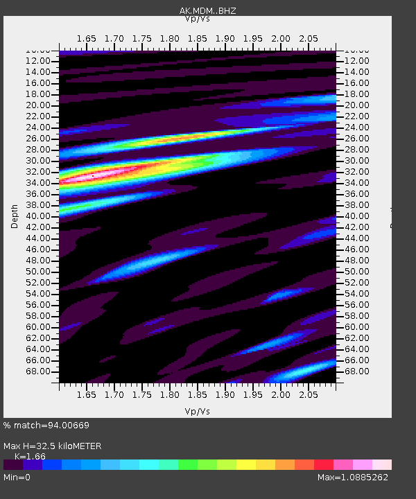
| Estimated Moho Depth: |
32.5 km |
| Estimated Crust Vp/Vs: |
1.66 |
| Assumed Crust Vp: |
6.566 km/s |
| Estimated Crust Vs: |
3.956 km/s |
| Estimated Crust Poisson's Ratio: |
0.22 |
|
| Radial Match: |
94.00669 % |
| Radial Bump: |
400 |
| Transverse Match: |
83.37613 % |
| Transverse Bump: |
400 |
| SOD ConfigId: |
30536071 |
| Insert Time: |
2023-04-01 17:17:00.915 +0000 |
| GWidth: |
2.5 |
| Max Bumps: |
400 |
| Tol: |
0.001 |
|
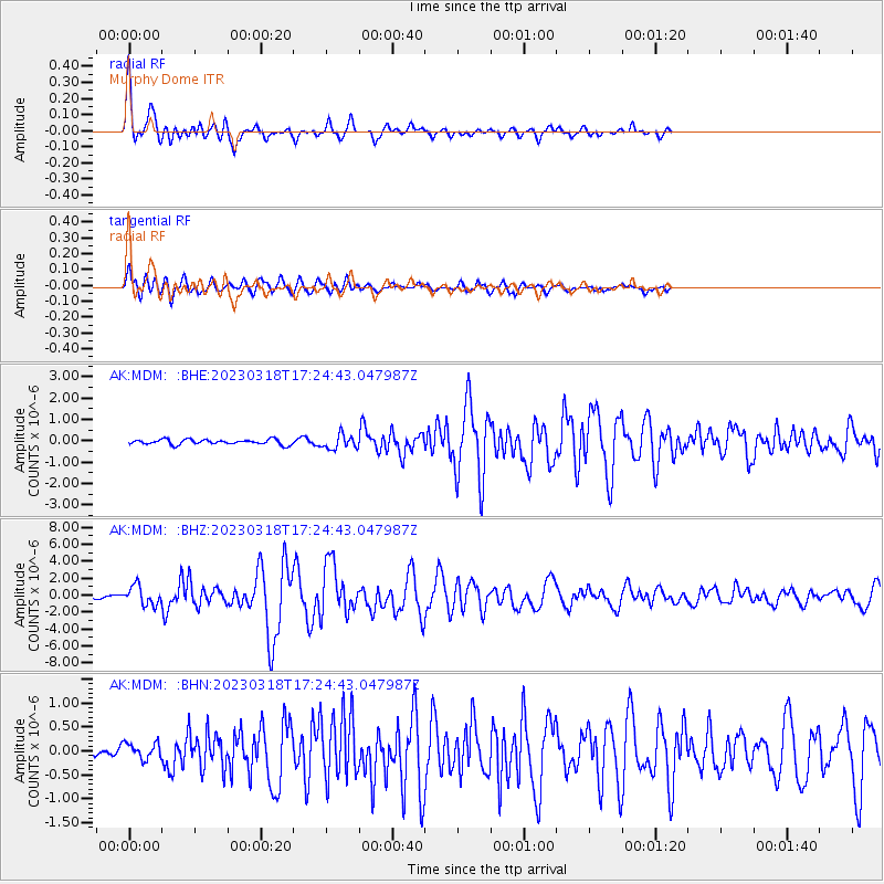
Signal To Noise
| Channel | StoN | STA | LTA |
| AK:MDM: :BHZ:20230318T17:24:43.047987Z | 4.9208403 | 1.1135878E-6 | 2.2630034E-7 |
| AK:MDM: :BHN:20230318T17:24:43.047987Z | 1.1608834 | 1.7298817E-7 | 1.4901424E-7 |
| AK:MDM: :BHE:20230318T17:24:43.047987Z | 2.8443265 | 3.3435197E-7 | 1.1755049E-7 |
| Arrivals |
| Ps | 3.4 SECOND |
| PpPs | 13 SECOND |
| PsPs/PpSs | 16 SECOND |


