You are here: Home > Network List > AK - Alaska Regional Network Stations List
> Station N15K Kwethluk River, AK, USA > Earthquake Result Viewer
N15K Kwethluk River, AK, USA - Earthquake Result Viewer
| Earthquake location: |
Near Coast Of Ecuador |
| Earthquake latitude/longitude: |
-2.9/-79.8 |
| Earthquake time(UTC): |
2023/03/18 (077) 17:12:53 GMT |
| Earthquake Depth: |
66 km |
| Earthquake Magnitude: |
6.7 Mww |
| Earthquake Catalog/Contributor: |
NEIC PDE/us |
|
| Network: |
AK Alaska Regional Network |
| Station: |
N15K Kwethluk River, AK, USA |
| Lat/Lon: |
60.17 N/160.09 W |
| Elevation: |
449 m |
|
| Distance: |
87.6 deg |
| Az: |
330.447 deg |
| Baz: |
99.829 deg |
| Ray Param: |
0.04306823 |
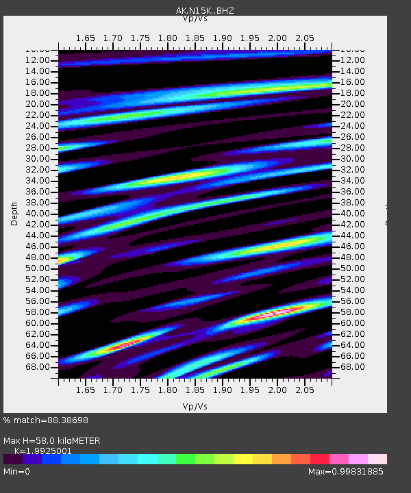
| Estimated Moho Depth: |
58.0 km |
| Estimated Crust Vp/Vs: |
1.99 |
| Assumed Crust Vp: |
6.182 km/s |
| Estimated Crust Vs: |
3.103 km/s |
| Estimated Crust Poisson's Ratio: |
0.33 |
|
| Radial Match: |
88.38698 % |
| Radial Bump: |
400 |
| Transverse Match: |
61.1519 % |
| Transverse Bump: |
400 |
| SOD ConfigId: |
30536071 |
| Insert Time: |
2023-04-01 17:17:04.070 +0000 |
| GWidth: |
2.5 |
| Max Bumps: |
400 |
| Tol: |
0.001 |
|

Signal To Noise
| Channel | StoN | STA | LTA |
| AK:N15K: :BHZ:20230318T17:25:02.940016Z | 5.224034 | 7.774281E-7 | 1.4881759E-7 |
| AK:N15K: :BHN:20230318T17:25:02.940016Z | 1.7846214 | 3.0424653E-7 | 1.7048241E-7 |
| AK:N15K: :BHE:20230318T17:25:02.940016Z | 1.8987345 | 3.622082E-7 | 1.9076295E-7 |
| Arrivals |
| Ps | 9.5 SECOND |
| PpPs | 28 SECOND |
| PsPs/PpSs | 37 SECOND |


