You are here: Home > Network List > AK - Alaska Regional Network Stations List
> Station O19K Port Alsworth, AK, USA > Earthquake Result Viewer
O19K Port Alsworth, AK, USA - Earthquake Result Viewer
| Earthquake location: |
Near Coast Of Ecuador |
| Earthquake latitude/longitude: |
-2.9/-79.8 |
| Earthquake time(UTC): |
2023/03/18 (077) 17:12:53 GMT |
| Earthquake Depth: |
66 km |
| Earthquake Magnitude: |
6.7 Mww |
| Earthquake Catalog/Contributor: |
NEIC PDE/us |
|
| Network: |
AK Alaska Regional Network |
| Station: |
O19K Port Alsworth, AK, USA |
| Lat/Lon: |
60.20 N/154.32 W |
| Elevation: |
96 m |
|
| Distance: |
84.8 deg |
| Az: |
331.091 deg |
| Baz: |
104.872 deg |
| Ray Param: |
0.04509098 |
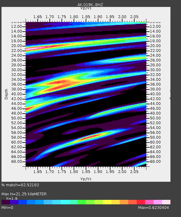
| Estimated Moho Depth: |
21.25 km |
| Estimated Crust Vp/Vs: |
1.60 |
| Assumed Crust Vp: |
6.566 km/s |
| Estimated Crust Vs: |
4.104 km/s |
| Estimated Crust Poisson's Ratio: |
0.18 |
|
| Radial Match: |
82.52183 % |
| Radial Bump: |
400 |
| Transverse Match: |
73.11764 % |
| Transverse Bump: |
400 |
| SOD ConfigId: |
30536071 |
| Insert Time: |
2023-04-01 17:17:15.006 +0000 |
| GWidth: |
2.5 |
| Max Bumps: |
400 |
| Tol: |
0.001 |
|

Signal To Noise
| Channel | StoN | STA | LTA |
| AK:O19K: :BHZ:20230318T17:24:49.200026Z | 2.2486053 | 6.5125084E-7 | 2.8962435E-7 |
| AK:O19K: :BHN:20230318T17:24:49.200026Z | 0.44085562 | 1.1101933E-7 | 2.5182695E-7 |
| AK:O19K: :BHE:20230318T17:24:49.200026Z | 1.3571324 | 2.6766153E-7 | 1.972258E-7 |
| Arrivals |
| Ps | 2.0 SECOND |
| PpPs | 8.2 SECOND |
| PsPs/PpSs | 10 SECOND |


