You are here: Home > Network List > AV - Alaska Volcano Observatory Stations List
> Station KAVE Katnai Ventifact, Alaska > Earthquake Result Viewer
KAVE Katnai Ventifact, Alaska - Earthquake Result Viewer
| Earthquake location: |
Near Coast Of Ecuador |
| Earthquake latitude/longitude: |
-2.9/-79.8 |
| Earthquake time(UTC): |
2023/03/18 (077) 17:12:53 GMT |
| Earthquake Depth: |
66 km |
| Earthquake Magnitude: |
6.7 Mww |
| Earthquake Catalog/Contributor: |
NEIC PDE/us |
|
| Network: |
AV Alaska Volcano Observatory |
| Station: |
KAVE Katnai Ventifact, Alaska |
| Lat/Lon: |
58.20 N/155.02 W |
| Elevation: |
702 m |
|
| Distance: |
84.7 deg |
| Az: |
329.052 deg |
| Baz: |
104.082 deg |
| Ray Param: |
0.045199513 |
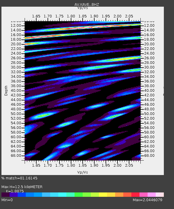
| Estimated Moho Depth: |
12.5 km |
| Estimated Crust Vp/Vs: |
1.89 |
| Assumed Crust Vp: |
6.438 km/s |
| Estimated Crust Vs: |
3.411 km/s |
| Estimated Crust Poisson's Ratio: |
0.30 |
|
| Radial Match: |
81.16145 % |
| Radial Bump: |
400 |
| Transverse Match: |
78.69123 % |
| Transverse Bump: |
400 |
| SOD ConfigId: |
30536071 |
| Insert Time: |
2023-04-01 17:18:59.890 +0000 |
| GWidth: |
2.5 |
| Max Bumps: |
400 |
| Tol: |
0.001 |
|
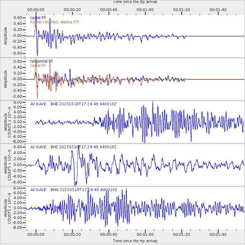
Signal To Noise
| Channel | StoN | STA | LTA |
| AV:KAVE: :BHZ:20230318T17:24:48.440016Z | 4.35662 | 9.1672496E-7 | 2.1042115E-7 |
| AV:KAVE: :BHN:20230318T17:24:48.440016Z | 1.2734642 | 4.347982E-7 | 3.4142948E-7 |
| AV:KAVE: :BHE:20230318T17:24:48.440016Z | 1.6594377 | 6.8118294E-7 | 4.1049023E-7 |
| Arrivals |
| Ps | 1.8 SECOND |
| PpPs | 5.5 SECOND |
| PsPs/PpSs | 7.2 SECOND |


