You are here: Home > Network List > AV - Alaska Volcano Observatory Stations List
> Station R17L Mt. Peulik Volcano, AVO PLK4, AK, USA > Earthquake Result Viewer
R17L Mt. Peulik Volcano, AVO PLK4, AK, USA - Earthquake Result Viewer
| Earthquake location: |
Near Coast Of Ecuador |
| Earthquake latitude/longitude: |
-2.9/-79.8 |
| Earthquake time(UTC): |
2023/03/18 (077) 17:12:53 GMT |
| Earthquake Depth: |
66 km |
| Earthquake Magnitude: |
6.7 Mww |
| Earthquake Catalog/Contributor: |
NEIC PDE/us |
|
| Network: |
AV Alaska Volcano Observatory |
| Station: |
R17L Mt. Peulik Volcano, AVO PLK4, AK, USA |
| Lat/Lon: |
57.63 N/156.36 W |
| Elevation: |
524 m |
|
| Distance: |
85.2 deg |
| Az: |
328.33 deg |
| Baz: |
102.888 deg |
| Ray Param: |
0.04479179 |
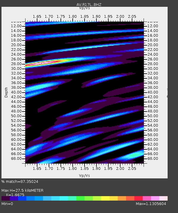
| Estimated Moho Depth: |
27.5 km |
| Estimated Crust Vp/Vs: |
1.67 |
| Assumed Crust Vp: |
6.1 km/s |
| Estimated Crust Vs: |
3.658 km/s |
| Estimated Crust Poisson's Ratio: |
0.22 |
|
| Radial Match: |
87.35024 % |
| Radial Bump: |
400 |
| Transverse Match: |
78.20684 % |
| Transverse Bump: |
400 |
| SOD ConfigId: |
30536071 |
| Insert Time: |
2023-04-01 17:19:41.748 +0000 |
| GWidth: |
2.5 |
| Max Bumps: |
400 |
| Tol: |
0.001 |
|

Signal To Noise
| Channel | StoN | STA | LTA |
| AV:R17L: :BHZ:20230318T17:24:51.250014Z | 3.355653 | 1.1931396E-6 | 3.555611E-7 |
| AV:R17L: :BHN:20230318T17:24:51.250014Z | 1.225236 | 4.3836772E-7 | 3.5778228E-7 |
| AV:R17L: :BHE:20230318T17:24:51.250014Z | 1.2219579 | 4.0303655E-7 | 3.298285E-7 |
| Arrivals |
| Ps | 3.1 SECOND |
| PpPs | 12 SECOND |
| PsPs/PpSs | 15 SECOND |


