You are here: Home > Network List > CC - Cascade Chain Volcano Monitoring Stations List
> Station PR05 Puyallup River 05 > Earthquake Result Viewer
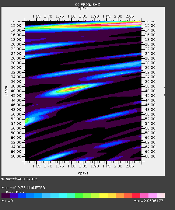
PR05 Puyallup River 05 - Earthquake Result Viewer
| Earthquake location: |
Near Coast Of Ecuador |
| Earthquake latitude/longitude: |
-2.9/-79.8 |
| Earthquake time(UTC): |
2023/03/18 (077) 17:12:53 GMT |
| Earthquake Depth: |
66 km |
| Earthquake Magnitude: |
6.7 Mww |
| Earthquake Catalog/Contributor: |
NEIC PDE/us |
|
| Network: |
CC Cascade Chain Volcano Monitoring |
| Station: |
PR05 Puyallup River 05 |
| Lat/Lon: |
46.84 N/121.95 W |
| Elevation: |
1553 m |
|
| Distance: |
61.8 deg |
| Az: |
328.49 deg |
| Baz: |
130.497 deg |
| Ray Param: |
0.060480874 |
| Estimated Moho Depth: |
10.75 km |
| Estimated Crust Vp/Vs: |
2.10 |
| Assumed Crust Vp: |
6.597 km/s |
| Estimated Crust Vs: |
3.145 km/s |
| Estimated Crust Poisson's Ratio: |
0.35 |
|
| Radial Match: |
83.34935 % |
| Radial Bump: |
400 |
| Transverse Match: |
78.38967 % |
| Transverse Bump: |
400 |
| SOD ConfigId: |
30536071 |
| Insert Time: |
2023-04-01 17:23:11.921 +0000 |
| GWidth: |
2.5 |
| Max Bumps: |
400 |
| Tol: |
0.001 |
|

Signal To Noise
| Channel | StoN | STA | LTA |
| CC:PR05: :BHZ:20230318T17:22:34.339979Z | 3.452587 | 3.6760338E-7 | 1.0647187E-7 |
| CC:PR05: :BHN:20230318T17:22:34.339979Z | 1.425635 | 1.8575429E-7 | 1.3029583E-7 |
| CC:PR05: :BHE:20230318T17:22:34.339979Z | 0.8117603 | 1.3424486E-7 | 1.65375E-7 |
| Arrivals |
| Ps | 1.9 SECOND |
| PpPs | 4.8 SECOND |
| PsPs/PpSs | 6.7 SECOND |


