You are here: Home > Network List > TA - USArray Transportable Network (new EarthScope stations) Stations List
> Station V26A Tequesquite Ranch, Mosquero, NM, USA > Earthquake Result Viewer
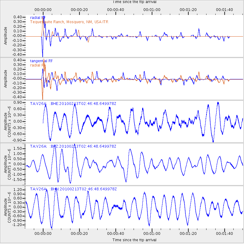
V26A Tequesquite Ranch, Mosquero, NM, USA - Earthquake Result Viewer
*The percent match for this event was below the threshold and hence no stack was calculated.
| Earthquake location: |
Tonga Islands |
| Earthquake latitude/longitude: |
-21.9/-174.8 |
| Earthquake time(UTC): |
2010/02/13 (044) 02:34:28 GMT |
| Earthquake Depth: |
11 km |
| Earthquake Magnitude: |
6.0 MB, 6.2 MS, 6.1 MW, 6.0 MW |
| Earthquake Catalog/Contributor: |
WHDF/NEIC |
|
| Network: |
TA USArray Transportable Network (new EarthScope stations) |
| Station: |
V26A Tequesquite Ranch, Mosquero, NM, USA |
| Lat/Lon: |
35.80 N/103.79 W |
| Elevation: |
1362 m |
|
| Distance: |
88.3 deg |
| Az: |
50.258 deg |
| Baz: |
241.448 deg |
| Ray Param: |
$rayparam |
*The percent match for this event was below the threshold and hence was not used in the summary stack. |
|
| Radial Match: |
78.302124 % |
| Radial Bump: |
400 |
| Transverse Match: |
45.87626 % |
| Transverse Bump: |
237 |
| SOD ConfigId: |
306082 |
| Insert Time: |
2010-05-06 07:22:22.285 +0000 |
| GWidth: |
2.5 |
| Max Bumps: |
400 |
| Tol: |
0.001 |
|
Signal To Noise
| Channel | StoN | STA | LTA |
| TA:V26A: :BHZ:20100213T02:46:48.649978Z | 2.0821114 | 8.178391E-7 | 3.927932E-7 |
| TA:V26A: :BHN:20100213T02:46:48.649978Z | 1.8021623 | 8.9998935E-7 | 4.9939416E-7 |
| TA:V26A: :BHE:20100213T02:46:48.649978Z | 0.51254743 | 2.270042E-7 | 4.4289405E-7 |
| Arrivals |
| Ps | |
| PpPs | |
| PsPs/PpSs | |


