You are here: Home > Network List > CN - Canadian National Seismograph Network Stations List
> Station ULM LAC DU BONNET, MB > Earthquake Result Viewer
ULM LAC DU BONNET, MB - Earthquake Result Viewer
| Earthquake location: |
Near Coast Of Ecuador |
| Earthquake latitude/longitude: |
-2.9/-79.8 |
| Earthquake time(UTC): |
2023/03/18 (077) 17:12:53 GMT |
| Earthquake Depth: |
66 km |
| Earthquake Magnitude: |
6.7 Mww |
| Earthquake Catalog/Contributor: |
NEIC PDE/us |
|
| Network: |
CN Canadian National Seismograph Network |
| Station: |
ULM LAC DU BONNET, MB |
| Lat/Lon: |
50.25 N/95.88 W |
| Elevation: |
251 m |
|
| Distance: |
54.7 deg |
| Az: |
347.416 deg |
| Baz: |
160.186 deg |
| Ray Param: |
0.06512471 |
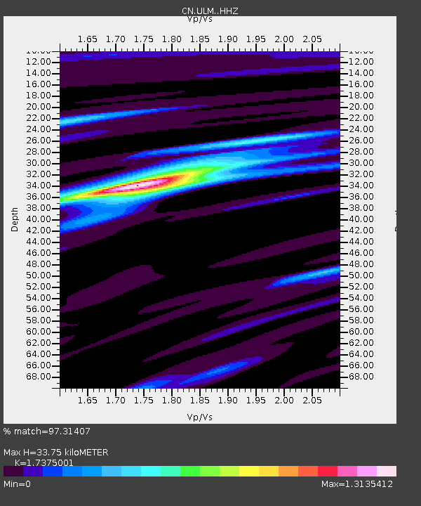
| Estimated Moho Depth: |
33.75 km |
| Estimated Crust Vp/Vs: |
1.74 |
| Assumed Crust Vp: |
6.459 km/s |
| Estimated Crust Vs: |
3.718 km/s |
| Estimated Crust Poisson's Ratio: |
0.25 |
|
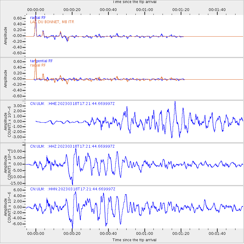
| Radial Match: |
97.31407 % |
| Radial Bump: |
225 |
| Transverse Match: |
90.506714 % |
| Transverse Bump: |
400 |
| SOD ConfigId: |
30536071 |
| Insert Time: |
2023-04-01 17:27:57.821 +0000 |
| GWidth: |
2.5 |
| Max Bumps: |
400 |
| Tol: |
0.001 |
|
Signal To Noise
| Channel | StoN | STA | LTA |
| CN:ULM: :HHZ:20230318T17:21:44.669997Z | 11.145882 | 2.0340187E-6 | 1.8249061E-7 |
| CN:ULM: :HHN:20230318T17:21:44.669997Z | 5.1647587 | 1.0404435E-6 | 2.0145058E-7 |
| CN:ULM: :HHE:20230318T17:21:44.669997Z | 3.0115147 | 4.514787E-7 | 1.499175E-7 |
| Arrivals |
| Ps | 4.1 SECOND |
| PpPs | 14 SECOND |
| PsPs/PpSs | 18 SECOND |


