You are here: Home > Network List > TA - USArray Transportable Network (new EarthScope stations) Stations List
> Station D19A Cripps Ranch, Grass Range, MT, USA > Earthquake Result Viewer
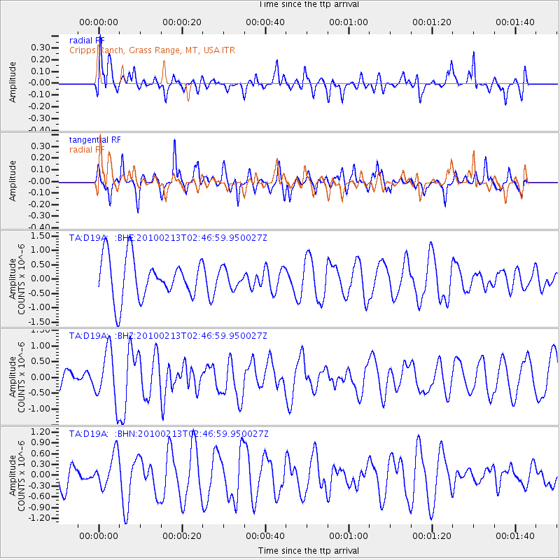
D19A Cripps Ranch, Grass Range, MT, USA - Earthquake Result Viewer
*The percent match for this event was below the threshold and hence no stack was calculated.
| Earthquake location: |
Tonga Islands |
| Earthquake latitude/longitude: |
-21.9/-174.8 |
| Earthquake time(UTC): |
2010/02/13 (044) 02:34:28 GMT |
| Earthquake Depth: |
11 km |
| Earthquake Magnitude: |
6.0 MB, 6.2 MS, 6.1 MW, 6.0 MW |
| Earthquake Catalog/Contributor: |
WHDF/NEIC |
|
| Network: |
TA USArray Transportable Network (new EarthScope stations) |
| Station: |
D19A Cripps Ranch, Grass Range, MT, USA |
| Lat/Lon: |
47.16 N/108.88 W |
| Elevation: |
1047 m |
|
| Distance: |
90.7 deg |
| Az: |
38.525 deg |
| Baz: |
237.964 deg |
| Ray Param: |
$rayparam |
*The percent match for this event was below the threshold and hence was not used in the summary stack. |
|
| Radial Match: |
67.16473 % |
| Radial Bump: |
400 |
| Transverse Match: |
53.076008 % |
| Transverse Bump: |
381 |
| SOD ConfigId: |
306082 |
| Insert Time: |
2010-05-06 07:23:16.642 +0000 |
| GWidth: |
2.5 |
| Max Bumps: |
400 |
| Tol: |
0.001 |
|
Signal To Noise
| Channel | StoN | STA | LTA |
| TA:D19A: :BHZ:20100213T02:46:59.950027Z | 1.8157607 | 8.4758574E-7 | 4.6679372E-7 |
| TA:D19A: :BHN:20100213T02:46:59.950027Z | 1.0617642 | 4.9357675E-7 | 4.648647E-7 |
| TA:D19A: :BHE:20100213T02:46:59.950027Z | 0.45115566 | 3.232685E-7 | 7.1653426E-7 |
| Arrivals |
| Ps | |
| PpPs | |
| PsPs/PpSs | |


