You are here: Home > Network List > ET - CERI Southern Appalachian seismic Network Stations List
> Station CPCT Cooper Cave,TN > Earthquake Result Viewer
CPCT Cooper Cave,TN - Earthquake Result Viewer
| Earthquake location: |
Near Coast Of Ecuador |
| Earthquake latitude/longitude: |
-2.9/-79.8 |
| Earthquake time(UTC): |
2023/03/18 (077) 17:12:53 GMT |
| Earthquake Depth: |
66 km |
| Earthquake Magnitude: |
6.7 Mww |
| Earthquake Catalog/Contributor: |
NEIC PDE/us |
|
| Network: |
ET CERI Southern Appalachian seismic Network |
| Station: |
CPCT Cooper Cave,TN |
| Lat/Lon: |
35.45 N/84.52 W |
| Elevation: |
275 m |
|
| Distance: |
38.4 deg |
| Az: |
353.782 deg |
| Baz: |
172.386 deg |
| Ray Param: |
0.07544388 |
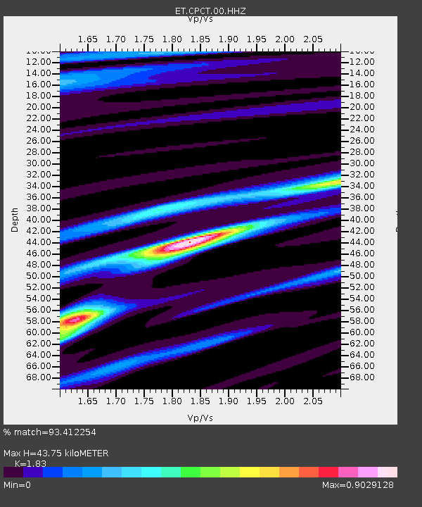
| Estimated Moho Depth: |
43.75 km |
| Estimated Crust Vp/Vs: |
1.83 |
| Assumed Crust Vp: |
6.35 km/s |
| Estimated Crust Vs: |
3.47 km/s |
| Estimated Crust Poisson's Ratio: |
0.29 |
|
| Radial Match: |
93.412254 % |
| Radial Bump: |
223 |
| Transverse Match: |
73.097176 % |
| Transverse Bump: |
400 |
| SOD ConfigId: |
30536071 |
| Insert Time: |
2023-04-01 17:29:02.894 +0000 |
| GWidth: |
2.5 |
| Max Bumps: |
400 |
| Tol: |
0.001 |
|

Signal To Noise
| Channel | StoN | STA | LTA |
| ET:CPCT:00:HHZ:20230318T17:19:37.280012Z | 9.368644 | 3.0606743E-6 | 3.2669342E-7 |
| ET:CPCT:00:HHN:20230318T17:19:37.280012Z | 8.092662 | 1.5480498E-6 | 1.9129055E-7 |
| ET:CPCT:00:HHE:20230318T17:19:37.280012Z | 1.6168264 | 2.945171E-7 | 1.8215752E-7 |
| Arrivals |
| Ps | 6.1 SECOND |
| PpPs | 18 SECOND |
| PsPs/PpSs | 24 SECOND |


