You are here: Home > Network List > TA - USArray Transportable Network (new EarthScope stations) Stations List
> Station W28A Vega, TX, USA > Earthquake Result Viewer
W28A Vega, TX, USA - Earthquake Result Viewer
| Earthquake location: |
Tonga Islands |
| Earthquake latitude/longitude: |
-21.9/-174.8 |
| Earthquake time(UTC): |
2010/02/13 (044) 02:34:28 GMT |
| Earthquake Depth: |
11 km |
| Earthquake Magnitude: |
6.0 MB, 6.2 MS, 6.1 MW, 6.0 MW |
| Earthquake Catalog/Contributor: |
WHDF/NEIC |
|
| Network: |
TA USArray Transportable Network (new EarthScope stations) |
| Station: |
W28A Vega, TX, USA |
| Lat/Lon: |
35.26 N/102.21 W |
| Elevation: |
1156 m |
|
| Distance: |
89.2 deg |
| Az: |
51.339 deg |
| Baz: |
242.386 deg |
| Ray Param: |
0.042050734 |
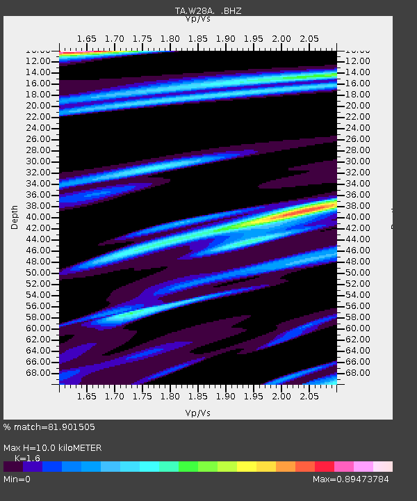
| Estimated Moho Depth: |
10.0 km |
| Estimated Crust Vp/Vs: |
1.60 |
| Assumed Crust Vp: |
6.242 km/s |
| Estimated Crust Vs: |
3.901 km/s |
| Estimated Crust Poisson's Ratio: |
0.18 |
|
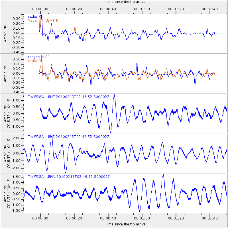
| Radial Match: |
81.901505 % |
| Radial Bump: |
400 |
| Transverse Match: |
68.89162 % |
| Transverse Bump: |
399 |
| SOD ConfigId: |
306082 |
| Insert Time: |
2010-05-06 07:24:17.228 +0000 |
| GWidth: |
2.5 |
| Max Bumps: |
400 |
| Tol: |
0.001 |
|
Signal To Noise
| Channel | StoN | STA | LTA |
| TA:W28A: :BHZ:20100213T02:46:52.800002Z | 3.0005922 | 1.164309E-6 | 3.880264E-7 |
| TA:W28A: :BHN:20100213T02:46:52.800002Z | 1.2080276 | 3.9168933E-7 | 3.242387E-7 |
| TA:W28A: :BHE:20100213T02:46:52.800002Z | 2.0054133 | 5.9815005E-7 | 2.982677E-7 |
| Arrivals |
| Ps | 1.0 SECOND |
| PpPs | 4.1 SECOND |
| PsPs/PpSs | 5.1 SECOND |


