You are here: Home > Network List > TA - USArray Transportable Network (new EarthScope stations) Stations List
> Station Z29A Hungry Hill Ranch, Wilson, TX, USA > Earthquake Result Viewer
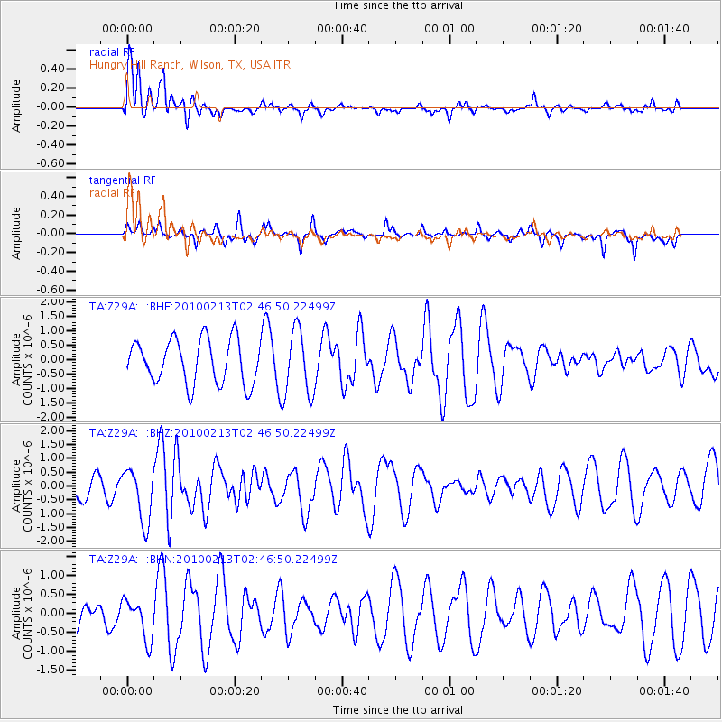
Z29A Hungry Hill Ranch, Wilson, TX, USA - Earthquake Result Viewer
*The percent match for this event was below the threshold and hence no stack was calculated.
| Earthquake location: |
Tonga Islands |
| Earthquake latitude/longitude: |
-21.9/-174.8 |
| Earthquake time(UTC): |
2010/02/13 (044) 02:34:28 GMT |
| Earthquake Depth: |
11 km |
| Earthquake Magnitude: |
6.0 MB, 6.2 MS, 6.1 MW, 6.0 MW |
| Earthquake Catalog/Contributor: |
WHDF/NEIC |
|
| Network: |
TA USArray Transportable Network (new EarthScope stations) |
| Station: |
Z29A Hungry Hill Ranch, Wilson, TX, USA |
| Lat/Lon: |
33.26 N/101.71 W |
| Elevation: |
938 m |
|
| Distance: |
88.6 deg |
| Az: |
53.299 deg |
| Baz: |
242.705 deg |
| Ray Param: |
$rayparam |
*The percent match for this event was below the threshold and hence was not used in the summary stack. |
|
| Radial Match: |
72.64575 % |
| Radial Bump: |
400 |
| Transverse Match: |
35.573013 % |
| Transverse Bump: |
229 |
| SOD ConfigId: |
306082 |
| Insert Time: |
2010-05-06 07:24:30.599 +0000 |
| GWidth: |
2.5 |
| Max Bumps: |
400 |
| Tol: |
0.001 |
|
Signal To Noise
| Channel | StoN | STA | LTA |
| TA:Z29A: :BHZ:20100213T02:46:50.22499Z | 2.30372 | 9.775972E-7 | 4.2435593E-7 |
| TA:Z29A: :BHN:20100213T02:46:50.22499Z | 0.80512017 | 5.307068E-7 | 6.591647E-7 |
| TA:Z29A: :BHE:20100213T02:46:50.22499Z | 1.4884115 | 1.1421507E-6 | 7.6736217E-7 |
| Arrivals |
| Ps | |
| PpPs | |
| PsPs/PpSs | |


