You are here: Home > Network List > TA - USArray Transportable Network (new EarthScope stations) Stations List
> Station 128A Castleberry Farm, Seminole, TX, USA > Earthquake Result Viewer
128A Castleberry Farm, Seminole, TX, USA - Earthquake Result Viewer

| Earthquake location: |
Tonga Islands |
| Earthquake latitude/longitude: |
-21.9/-174.8 |
| Earthquake time(UTC): |
2010/02/13 (044) 02:34:28 GMT |
| Earthquake Depth: |
11 km |
| Earthquake Magnitude: |
6.0 MB, 6.2 MS, 6.1 MW, 6.0 MW |
| Earthquake Catalog/Contributor: |
WHDF/NEIC |
|
| Network: |
TA USArray Transportable Network (new EarthScope stations) |
| Station: |
128A Castleberry Farm, Seminole, TX, USA |
| Lat/Lon: |
32.62 N/102.49 W |
| Elevation: |
966 m |
|
| Distance: |
87.7 deg |
| Az: |
53.561 deg |
| Baz: |
242.292 deg |
| Ray Param: |
0.04310788 |
| Estimated Moho Depth: |
15.25 km |
| Estimated Crust Vp/Vs: |
2.09 |
| Assumed Crust Vp: |
6.129 km/s |
| Estimated Crust Vs: |
2.94 km/s |
| Estimated Crust Poisson's Ratio: |
0.35 |
|
| Radial Match: |
82.459175 % |
| Radial Bump: |
400 |
| Transverse Match: |
64.14768 % |
| Transverse Bump: |
283 |
| SOD ConfigId: |
306082 |
| Insert Time: |
2010-05-06 07:24:33.042 +0000 |
| GWidth: |
2.5 |
| Max Bumps: |
400 |
| Tol: |
0.001 |
|
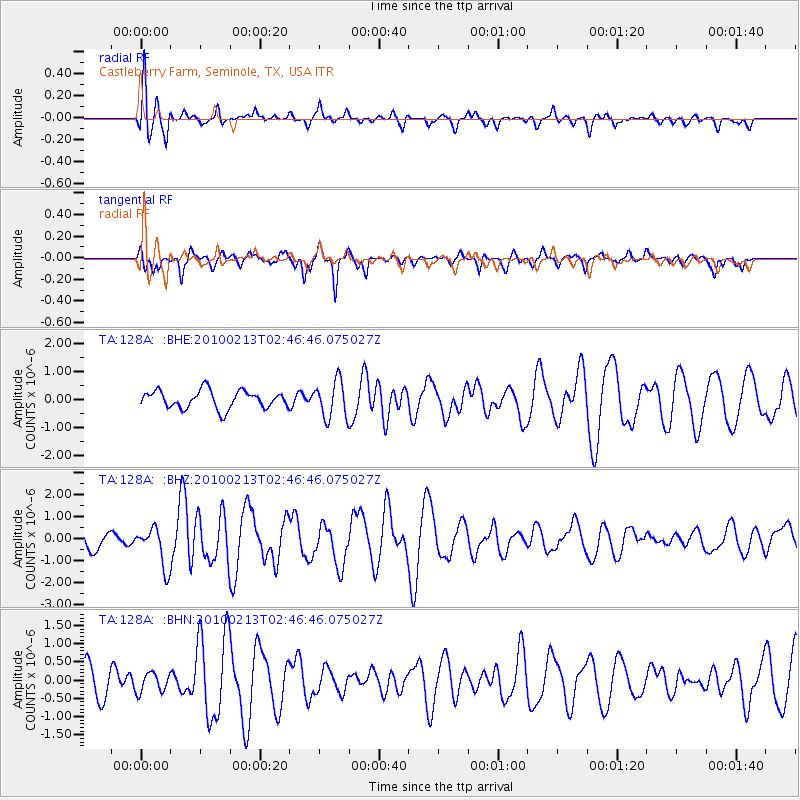
Signal To Noise
| Channel | StoN | STA | LTA |
| TA:128A: :BHZ:20100213T02:46:46.075027Z | 2.1994543 | 8.919072E-7 | 4.0551296E-7 |
| TA:128A: :BHN:20100213T02:46:46.075027Z | 0.5231243 | 2.671493E-7 | 5.1068037E-7 |
| TA:128A: :BHE:20100213T02:46:46.075027Z | 2.0965908 | 6.657759E-7 | 3.1755167E-7 |
| Arrivals |
| Ps | 2.7 SECOND |
| PpPs | 7.5 SECOND |
| PsPs/PpSs | 10 SECOND |


