You are here: Home > Network List > GM - US Geological Survey Networks Stations List
> Station NMP41 New Mexico Permian - Site# W4S1 > Earthquake Result Viewer
NMP41 New Mexico Permian - Site# W4S1 - Earthquake Result Viewer
| Earthquake location: |
Near Coast Of Ecuador |
| Earthquake latitude/longitude: |
-2.9/-79.8 |
| Earthquake time(UTC): |
2023/03/18 (077) 17:12:53 GMT |
| Earthquake Depth: |
66 km |
| Earthquake Magnitude: |
6.7 Mww |
| Earthquake Catalog/Contributor: |
NEIC PDE/us |
|
| Network: |
GM US Geological Survey Networks |
| Station: |
NMP41 New Mexico Permian - Site# W4S1 |
| Lat/Lon: |
32.01 N/103.60 W |
| Elevation: |
960 m |
|
| Distance: |
41.4 deg |
| Az: |
328.763 deg |
| Baz: |
142.436 deg |
| Ray Param: |
0.073627025 |
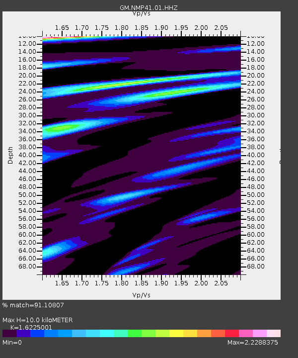
| Estimated Moho Depth: |
10.0 km |
| Estimated Crust Vp/Vs: |
1.62 |
| Assumed Crust Vp: |
6.129 km/s |
| Estimated Crust Vs: |
3.777 km/s |
| Estimated Crust Poisson's Ratio: |
0.19 |
|
| Radial Match: |
91.10807 % |
| Radial Bump: |
400 |
| Transverse Match: |
73.35873 % |
| Transverse Bump: |
400 |
| SOD ConfigId: |
30536071 |
| Insert Time: |
2023-04-01 17:30:38.333 +0000 |
| GWidth: |
2.5 |
| Max Bumps: |
400 |
| Tol: |
0.001 |
|

Signal To Noise
| Channel | StoN | STA | LTA |
| GM:NMP41:01:HHZ:20230318T17:20:02.284987Z | 8.908631 | 2.1689195E-6 | 2.4346272E-7 |
| GM:NMP41:01:HHN:20230318T17:20:02.284987Z | 2.4756906 | 6.8344946E-7 | 2.7606416E-7 |
| GM:NMP41:01:HHE:20230318T17:20:02.284987Z | 2.2904189 | 5.66312E-7 | 2.4725261E-7 |
| Arrivals |
| Ps | 1.1 SECOND |
| PpPs | 4.0 SECOND |
| PsPs/PpSs | 5.1 SECOND |


