You are here: Home > Network List > GT - Global Telemetered Seismograph Network (USAF/USGS) Stations List
> Station PLCA Paso Flores, Argentina > Earthquake Result Viewer
PLCA Paso Flores, Argentina - Earthquake Result Viewer
| Earthquake location: |
Near Coast Of Ecuador |
| Earthquake latitude/longitude: |
-2.9/-79.8 |
| Earthquake time(UTC): |
2023/03/18 (077) 17:12:53 GMT |
| Earthquake Depth: |
66 km |
| Earthquake Magnitude: |
6.7 Mww |
| Earthquake Catalog/Contributor: |
NEIC PDE/us |
|
| Network: |
GT Global Telemetered Seismograph Network (USAF/USGS) |
| Station: |
PLCA Paso Flores, Argentina |
| Lat/Lon: |
40.73 S/70.55 W |
| Elevation: |
1080 m |
|
| Distance: |
38.6 deg |
| Az: |
168.716 deg |
| Baz: |
345.098 deg |
| Ray Param: |
0.07528605 |
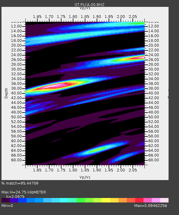
| Estimated Moho Depth: |
24.75 km |
| Estimated Crust Vp/Vs: |
2.10 |
| Assumed Crust Vp: |
6.597 km/s |
| Estimated Crust Vs: |
3.145 km/s |
| Estimated Crust Poisson's Ratio: |
0.35 |
|
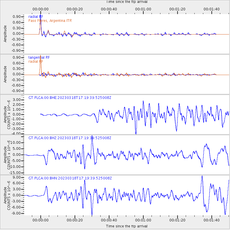
| Radial Match: |
95.44789 % |
| Radial Bump: |
241 |
| Transverse Match: |
85.53052 % |
| Transverse Bump: |
400 |
| SOD ConfigId: |
30536071 |
| Insert Time: |
2023-04-01 17:31:14.345 +0000 |
| GWidth: |
2.5 |
| Max Bumps: |
400 |
| Tol: |
0.001 |
|
Signal To Noise
| Channel | StoN | STA | LTA |
| GT:PLCA:00:BHZ:20230318T17:19:39.525008Z | 13.235612 | 3.3493136E-6 | 2.5305317E-7 |
| GT:PLCA:00:BHN:20230318T17:19:39.525008Z | 10.322931 | 2.0915063E-6 | 2.0260781E-7 |
| GT:PLCA:00:BHE:20230318T17:19:39.525008Z | 5.7978787 | 7.291486E-7 | 1.2576128E-7 |
| Arrivals |
| Ps | 4.4 SECOND |
| PpPs | 11 SECOND |
| PsPs/PpSs | 15 SECOND |


