You are here: Home > Network List > TA - USArray Transportable Network (new EarthScope stations) Stations List
> Station H28A Mission Ridge, SD, USA > Earthquake Result Viewer
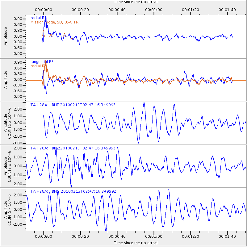
H28A Mission Ridge, SD, USA - Earthquake Result Viewer
*The percent match for this event was below the threshold and hence no stack was calculated.
| Earthquake location: |
Tonga Islands |
| Earthquake latitude/longitude: |
-21.9/-174.8 |
| Earthquake time(UTC): |
2010/02/13 (044) 02:34:28 GMT |
| Earthquake Depth: |
11 km |
| Earthquake Magnitude: |
6.0 MB, 6.2 MS, 6.1 MW, 6.0 MW |
| Earthquake Catalog/Contributor: |
WHDF/NEIC |
|
| Network: |
TA USArray Transportable Network (new EarthScope stations) |
| Station: |
H28A Mission Ridge, SD, USA |
| Lat/Lon: |
44.68 N/101.02 W |
| Elevation: |
642 m |
|
| Distance: |
94.3 deg |
| Az: |
43.381 deg |
| Baz: |
243.386 deg |
| Ray Param: |
$rayparam |
*The percent match for this event was below the threshold and hence was not used in the summary stack. |
|
| Radial Match: |
77.32201 % |
| Radial Bump: |
400 |
| Transverse Match: |
51.369255 % |
| Transverse Bump: |
385 |
| SOD ConfigId: |
306082 |
| Insert Time: |
2010-05-06 07:26:41.411 +0000 |
| GWidth: |
2.5 |
| Max Bumps: |
400 |
| Tol: |
0.001 |
|
Signal To Noise
| Channel | StoN | STA | LTA |
| TA:H28A: :BHZ:20100213T02:47:16.34999Z | 1.3952641 | 1.0499069E-6 | 7.5247897E-7 |
| TA:H28A: :BHN:20100213T02:47:16.34999Z | 0.87199825 | 1.2657014E-6 | 1.4514953E-6 |
| TA:H28A: :BHE:20100213T02:47:16.34999Z | 0.6936877 | 6.962151E-7 | 1.0036435E-6 |
| Arrivals |
| Ps | |
| PpPs | |
| PsPs/PpSs | |


