You are here: Home > Network List > LM - Michigan State University Seismic Network Stations List
> Station NHBP Nengshka Wabeno, Nottawaseppi Huron Band of the Potawatomi > Earthquake Result Viewer
NHBP Nengshka Wabeno, Nottawaseppi Huron Band of the Potawatomi - Earthquake Result Viewer
| Earthquake location: |
Near Coast Of Ecuador |
| Earthquake latitude/longitude: |
-2.9/-79.8 |
| Earthquake time(UTC): |
2023/03/18 (077) 17:12:53 GMT |
| Earthquake Depth: |
66 km |
| Earthquake Magnitude: |
6.7 Mww |
| Earthquake Catalog/Contributor: |
NEIC PDE/us |
|
| Network: |
LM Michigan State University Seismic Network |
| Station: |
NHBP Nengshka Wabeno, Nottawaseppi Huron Band of the Potawatomi |
| Lat/Lon: |
42.10 N/85.27 W |
| Elevation: |
226 m |
|
| Distance: |
45.0 deg |
| Az: |
354.247 deg |
| Baz: |
172.269 deg |
| Ray Param: |
0.07136231 |
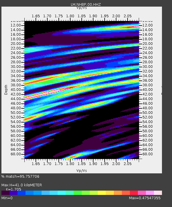
| Estimated Moho Depth: |
41.0 km |
| Estimated Crust Vp/Vs: |
1.71 |
| Assumed Crust Vp: |
6.483 km/s |
| Estimated Crust Vs: |
3.802 km/s |
| Estimated Crust Poisson's Ratio: |
0.24 |
|
| Radial Match: |
95.757706 % |
| Radial Bump: |
286 |
| Transverse Match: |
73.42628 % |
| Transverse Bump: |
400 |
| SOD ConfigId: |
30536071 |
| Insert Time: |
2023-04-01 17:33:01.329 +0000 |
| GWidth: |
2.5 |
| Max Bumps: |
400 |
| Tol: |
0.001 |
|

Signal To Noise
| Channel | StoN | STA | LTA |
| LM:NHBP:00:HHZ:20230318T17:20:31.530012Z | 7.7271957 | 2.2336587E-6 | 2.890646E-7 |
| LM:NHBP:00:HHN:20230318T17:20:31.530012Z | 8.294793 | 1.6084108E-6 | 1.9390606E-7 |
| LM:NHBP:00:HHE:20230318T17:20:31.530012Z | 1.9972713 | 5.5598804E-7 | 2.7837382E-7 |
| Arrivals |
| Ps | 4.8 SECOND |
| PpPs | 16 SECOND |
| PsPs/PpSs | 21 SECOND |


