You are here: Home > Network List > N4 - Central and EAstern US Network Stations List
> Station I49A Point Hope, MI, USA > Earthquake Result Viewer
I49A Point Hope, MI, USA - Earthquake Result Viewer
| Earthquake location: |
Near Coast Of Ecuador |
| Earthquake latitude/longitude: |
-2.9/-79.8 |
| Earthquake time(UTC): |
2023/03/18 (077) 17:12:53 GMT |
| Earthquake Depth: |
66 km |
| Earthquake Magnitude: |
6.7 Mww |
| Earthquake Catalog/Contributor: |
NEIC PDE/us |
|
| Network: |
N4 Central and EAstern US Network |
| Station: |
I49A Point Hope, MI, USA |
| Lat/Lon: |
43.94 N/82.82 W |
| Elevation: |
217 m |
|
| Distance: |
46.7 deg |
| Az: |
356.996 deg |
| Baz: |
175.845 deg |
| Ray Param: |
0.07031438 |
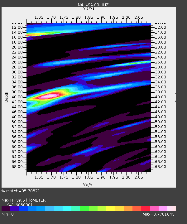
| Estimated Moho Depth: |
39.5 km |
| Estimated Crust Vp/Vs: |
1.69 |
| Assumed Crust Vp: |
6.483 km/s |
| Estimated Crust Vs: |
3.847 km/s |
| Estimated Crust Poisson's Ratio: |
0.23 |
|
| Radial Match: |
95.78571 % |
| Radial Bump: |
230 |
| Transverse Match: |
76.6994 % |
| Transverse Bump: |
400 |
| SOD ConfigId: |
30536071 |
| Insert Time: |
2023-04-01 17:34:12.927 +0000 |
| GWidth: |
2.5 |
| Max Bumps: |
400 |
| Tol: |
0.001 |
|

Signal To Noise
| Channel | StoN | STA | LTA |
| N4:I49A:00:HHZ:20230318T17:20:44.478987Z | 5.68639 | 2.5241513E-6 | 4.4389347E-7 |
| N4:I49A:00:HH1:20230318T17:20:44.478987Z | 4.0864334 | 1.5622919E-6 | 3.8231187E-7 |
| N4:I49A:00:HH2:20230318T17:20:44.478987Z | 1.204224 | 4.159335E-7 | 3.4539545E-7 |
| Arrivals |
| Ps | 4.5 SECOND |
| PpPs | 15 SECOND |
| PsPs/PpSs | 20 SECOND |


